
2014-10-21/22: onstuimig met zware windstoten en onweerkans
20-10-2014 08:01 - Skywarn NL forum - Relevant 21-10-2014/22-10-2014
Skywarn forum: Windhoos Wildervank/Veendam/Scheemda
18-10-2014 12:00 - Skywarn NL forum - Relevant 17-10-2014
Schadeanalyse na windhoos/tornado Zelhem gisteren
12-10-2014 18:16 - Weerwoord - Relevant 11-10-2014
Schadeanalyse ter plaatse (dag later)
12-10-2014 12:00 - Weerwoord - Relevant 11-10-2014
Wateroverlast 20 september 2014!!
21-09-2014 12:00 - YouTube - Relevant 20-09-2014

HuismanMedia: Noodweer zorgt voor overlast in Oost Groningen (video)
21-09-2014 12:00 - YouTube - Relevant 20-09-2014
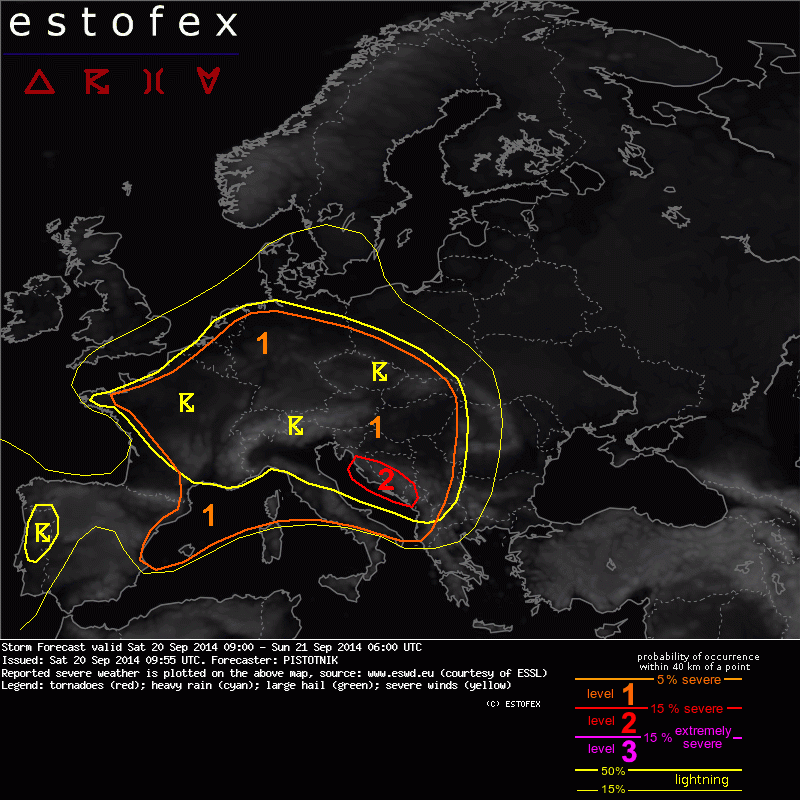
Storm Forecast valid: Sat 20 Sep 2014 09:00 to Sun 21 Sep 2014 06:00UTC
20-09-2014 12:00 - Estofex - Relevant 20-09-2014/21-09-2014
12/08/14 - Fotogenieke regiochase
01-09-2014 12:00 - Hans' Weerweb - Relevant 12-08-2014

Hoosfoto's van vanmiddag
24-08-2014 21:13 - Weerwoord - Relevant 24-08-2014
De schade van een paar uur Bertha: deel 2
19-08-2014 02:32 - Weerwoord - Relevant 10-08-2014
Foto slecht zicht/zware neerslag met hagel
13-08-2014 20:00 - Skywarn NL waarnemer - Relevant 12-08-2014

2014-08-12: onweerskansen NL met tweedeling :-)
12-08-2014 09:54 - Skywarn NL forum - Relevant 12-08-2014
Code geel voor Onweer en Waterhozen
05-08-2014 15:23 - Weerwoord - Relevant 05-08-2014
2014-08-03: onweer voor het zuiden en oosten van Nl
03-08-2014 15:51 - Skywarn NL forum - Relevant 03-08-2014
Weerkundige reconstructies als objectief antwoord
28-07-2014 12:00 - KNMI - Relevant 28-07-2014
2014-07-28: buien met onweer en opnieuw veel neerslag
28-07-2014 08:38 - Skywarn NL forum - Relevant 28-07-2014
Funnel-waarneming tegen 17:00 lt vanuit Zwijndrecht
27-07-2014 20:21 - Weerwoord - Relevant 27-07-2014
2014-07-27: opnieuw onweersbuien met lokaal veel neerslag
27-07-2014 07:50 - Skywarn NL forum - Relevant 27-07-2014
Funnelwaarneming omg. Haarlem
26-07-2014 19:52 - Weerwoord - Relevant 26-07-2014
2014-07-12 en 13 Convergentie rules!
12-07-2014 07:18 - Skywarn NL forum - Relevant 12-07-2014/13-07-2014