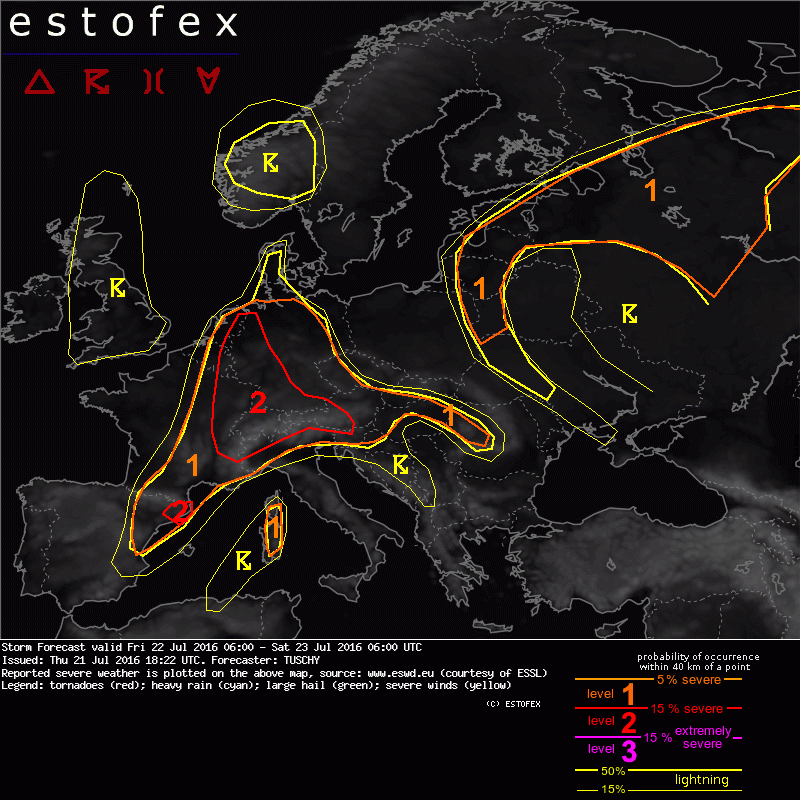
02/03/2025 (niet ingelogd)

Weer in het nieuws

Filter

<<<92/134>>>

Storm Forecast valid: Tue 22 May 2018 06:00 to Wed 23 May 2018 06:00UTC
21-05-2018 22:18 - Estofex | m.b.t. 22-05-2018 t/m 23-05-2018
A level 1 covers a large part of Europe mainly for excessive precipitation and large hail and to a lesser extent severe convective wind gusts.
Bij toeval windsnelheid gemeten in Tornado Viersen (223 km/u)
17-05-2018 10:56 - Weerwoord | m.b.t. 16-05-2018
YouTube: In einem Tornado! Boisheim, Deutschland | 16 05 2018
16-05-2018 22:19 - Redactie | m.b.t. 16-05-2018
Grote hagel +/- 3 tot 3,5 cm gezien te Krefeld (Dld)
16-05-2018 18:10 - Weerwoord | m.b.t. 16-05-2018
Storm Forecast valid Sun 13 May 2018 06:00 to Mon 14 May 2018 06:00UTC
12-05-2018 20:11 - Estofex | m.b.t. 13-05-2018 t/m 14-05-2018
A level 2 was issued across parts of Germany and the Northeast Netherlands mainly for extreme rainfall, and to a lesser extent for large hail.
A level 1 was issued across large portions of Central Europe and the West Balkans for extreme rainfall and large hail. 
Climatological Aspects of Convective Parameters over Europe: A Comparison of ERA
06-05-2018 12:00 - European Severe Storms Laboratory (ESSL) | m.b.t. 06-05-2018
"If you are interested in the convective parameters which we use for forecasting severe thunderstorms in Europe check out new research paper "Climatological Aspects of Convective Parameters over Europe: A Comparison of ERA-Interim and Sounding Data " co-authored by the members of ESTOFEX.
Mesoscale Discussion Valid Sun 29 Apr 2018 19:00 to Sun 29 Apr 2018 22:0
29-04-2018 19:21 - Estofex | m.b.t. 29-04-2018
Convective coverage has increased markedly over the MD area, with a line of supercells stretching from Luxembourg southward across Northeast France. In addition, new cells initiating over Luxembourg and a small MCS over Central Belgium is moving northward.
Mesoscale Discussion Valid Sun 29 Apr 2018 16:00 to Sun 29 Apr 2018 19:0
29-04-2018 16:25 - Estofex | m.b.t. 29-04-2018
An intense supercell near Chalons-en-Champagne at 1615 UTC is rapidly moving northward across the MD area along a stationary front with cold 10-13 C air to its west and relatively warm 20-23 C air to its east. It is likely producing severe wind gusts and large hail.
Storm Forecast valid Sun 29 Apr 2018 06:00 to Mon 30 Apr 2018 06:00UTC
28-04-2018 18:33 - Estofex | m.b.t. 29-04-2018 t/m 30-04-2018
A level 2 was issued across E-France, extreme W-Germany and Luxembourg for large hail, severe wind gusts, excessive rainfall and an isolated tornado event. A level 1 surrounds the level 2 with similar risks but lower probabilities.
Extended Forecast Valid Sun 29 Apr 2018 06:00 to Mon 30 Apr 2018 06:00UTC
27-04-2018 14:58 - Estofex | m.b.t. 29-04-2018 t/m 30-04-2018
A level 1 was issued across for tornadoes, hail, very heavy rainfall and wind gusts across Northeast France, Luxembourg, East Belgium, West Germany and Southeast Netherlands.

<<<92/134>>>