
22-07-2017 01:18 | Estofex | m.b.t. 22-07-2017 t/m 23-07-2017
Storm Forecast
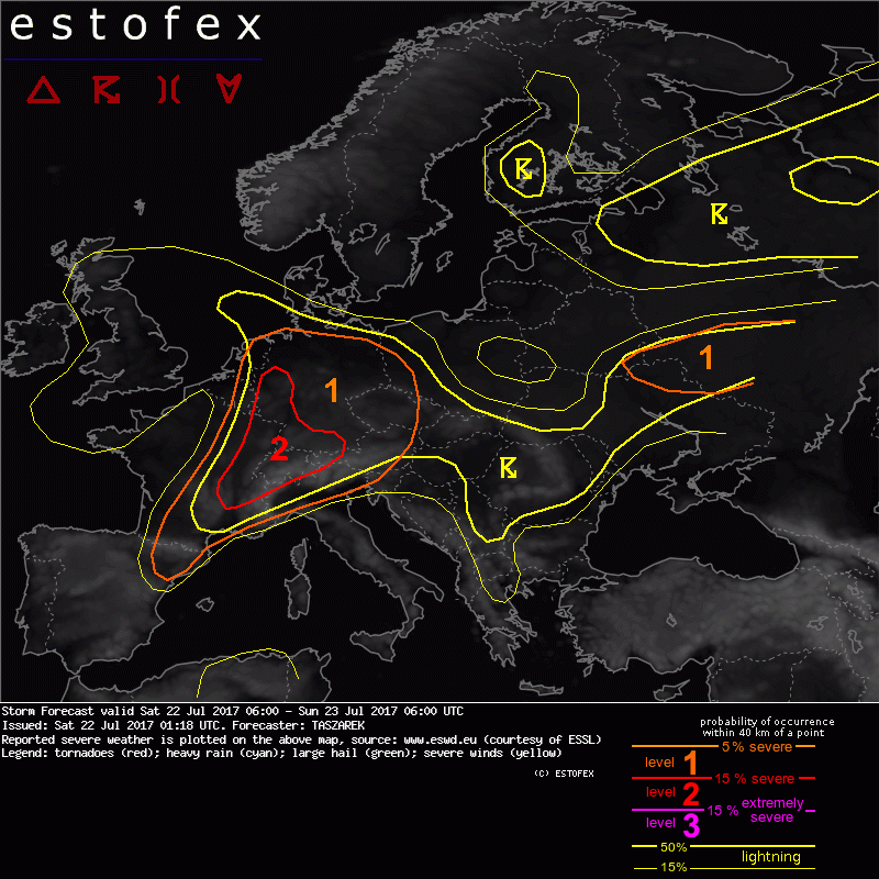
Valid: Sat 22 Jul 2017 06:00 to Sun 23 Jul 2017 06:00 UTC
Issued: Sat 22 Jul 2017 01:18
Forecaster: TASZAREK
A level 2 was issued for E France, Switzerland and parts of W and S Germany mainly for the excessive precipitation, large hail and severe wind gusts.
A level 1 was issued for E Benelux, Germany, Czech Republic, SW Poland, W Austria, N Italy, E and S France and NE Spain mainly for excessive precipitation, large hail and severe wind gusts.
A level 1 was issued for N Ukraine and parts of W Russia mainly for excessive precipitation, large hail and severe wind gusts.
SYNOPSIS
A large cutting-off low is located over British Isles and slowly moves eastwards. On its southern flank, it is encircled by jet stream with difluent flow in a warm sector over France, Benelux, W Alps and Germany. Ridge inhibiting convective activity covers Scandinavia and Poland. Broad low with a stationary frontal boundary is located over NW Russia. Moist and unstable airmass remains in the broad zone with weak horizontal pressure gradient extending from E Spain, through N Italy, CNTRL and SE Europe, up to Ukraine and parts of W Russia. Given the support of strong diurnal heating, the main thunderstorm activity on Saturday is expected within aforementioned area. Heavily capped airmass preventing from CI is located over W and CNTRL Mediterranean.
DISCUSSION
...parts of W and CNTRL Europe...
Eastern flank of incoming trough from British Isles consists of 10-11 g/kg mixing ratios and moderate lapse rates (~ 6.75 K/km), which produces a broad area of instability over E / S France, and a large part of CNTRL Europe. Strong diurnal heating and increasing rate of evapotranspiration should overcome rather weak CIN and provide CI in the afternoon hours, mostly considering area of Alps, France and Germany. CNTRL and NE Germany should also experience storm activity in the morning hours as a result of fading MCS from Friday. This system may be capable of producing heavy precipitation and in lesser extent severe wind gusts. Storms developing over France, Switzerland and parts of S Germany are expected to have better severe weather potential, mainly due to the influence of a jet stream which may support well organized storms such as supercells or linear multicell clusters. Current mesoscale NWP scenarios are not consistent, but it is likely that first cells will develop over W Germany and E France and move north-eastward. Further development is expected over Switzerland and S Germany. Thanks to better wind profile and stronger QG-lift, storms over France and Switzerland have higher probability to develop into supercells capable of producing large hail (lapse rate > 7 K/km), severe wind and heavy rain (PW > 30mm). In the late afternoon hours, these storm may form an MCS which during nighttime hours will move to Czech Republic and E Germany. Another storm system in the form of the line is expected to develop in the late afternoon hours over NE France / SE Benelux and W Germany. Although instability over this time will be rather small, the support of a large-scale lift and enhanced flow at 700 hPa with 15 m/s MLS may help to maintain convective activity until night. A bowing segments with a potential of producing severe wind gusts are not ruled out within this system. Storms should fade over N-CNTRL Germany, while the main activity during nighttime should shift to N Benelux and North Sea.
(alleen de voor NL en direct aangrenzende gebieden relevante tekstdelen overgenomen, klik hier voor de volledige forecast, red.)
Hagel(-schade) | Verwachtingen/waarschuwingen | Wateroverlast/(zware) neerslag | Wind/storm (-schade)
