
06-07-2017 12:00 | Estofex | m.b.t. 06-07-2017 t/m 07-07-2017
Storm Forecast
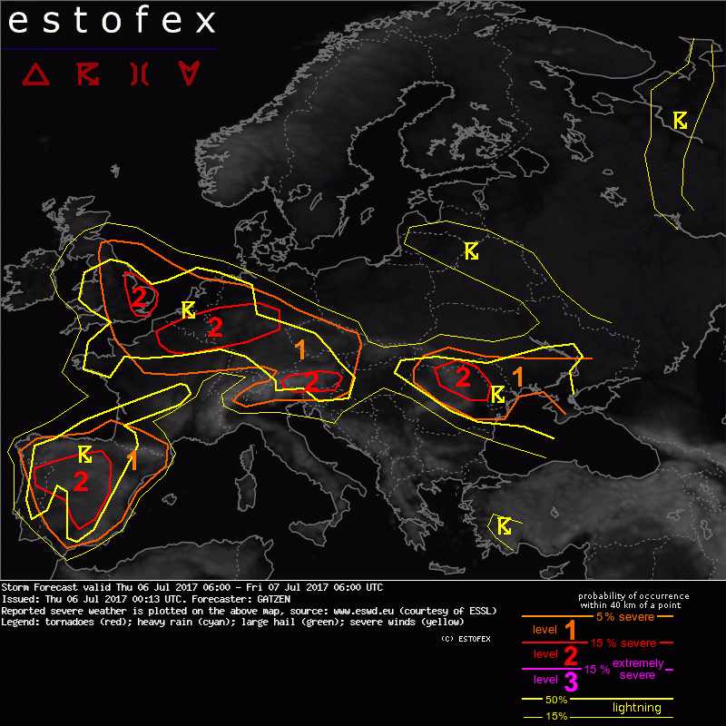
Valid: Thu 06 Jul 2017 06:00 to Fri 07 Jul 2017 06:00 UTC
Issued: Thu 06 Jul 2017 00:13
Forecaster: GATZEN
A level 2 was issued for western Spain and northern Portugal mainly for severe wind gusts, large hail, and excessive precipitation and to a lesser extent for tornadoes.
A level 1 was issued for eastern Spain and southern France mainly for large hail and severe wind gusts.
A level 2 was issued for eastern England, northern France into Benelux and northern and central Germany mainly for severe wind gusts and large hail and to a lesser extent excessive precipitation.
A level 2 was issued for southern Austria and surroundings mainly for large hail and excessive precipitation and to a lesser extent severe wind gusts.
A level 1 was issued for the Czech Republic, southern Germany, and eastern Austria mainly for large hail and excessive precipitation.
A level 1 was issued for northern Italy mainly for large hail and excessive precipitation.
A level 2 was issued for northern Romania mainly for large hail and severe wind gusts and to a lesser extent excessive precipitation.
A level 1 was issued for Moldova and Ukraine mainly for excessive precipitation.
SYNOPSIS
Low geopotential across northern Europe yields a westerly mid-level flow over the central parts of Europe. Embedded short-wave troughs travel eastwards during the period. Over southern Europe, intense cut-off low is situated over Portugal and slowly moves east. It will be a focus of convective storms on Thursday. Downstream African high ridges into western and central Europe, associated with an elevated mixed layer spreading across western Europe. Along the northern edge of the EML, cyclogenesis is expected as a short-wave trough overspreads the warm front late in the period. Broader low geopotential can be found further east centred across Turkey.
DISCUSSION
England, northern France, Benelux, northern and central Germany into the Czech Republic
Plume of warm and unstable air masses spreads eastwards on Thursday. Axis of this warm air is expected over The Channel in the morning and noon hours. Strong warm air advection could result in clusters of storms forming early in the period spreading eastward along the warm front. Weak surface-based CAPE limits the severe potential of these storms, but they could be maintained due to frontogenetical forcing on their way to the Benelux countries and north-western Germany. If these storms manage to root the boundary-layer, favourably curved hodographs indicate a risk of supercells, capable of producing large hail and severe wind gusts.
In the afternoon, some storms are possible further south-east over the mountains of central or southern Germany as well as the Czech Republic. Vertical wind shear is weak to moderate, allowing for multicells that can merge to clusters and travel eastward. Large hail is possible, as well as severe wind gusts and excessive rain. Weak low-level convergence may limit storm initiation, though.
Later in the period, approaching short-wave trough from the west is expected. With evolving southerly low-level flow, warm air advection along the edges of the warm plume increases especially over northern France and the south-eastern UK. Latest models agree in strong moisture increase below the EML along the warm front and moderate to high CAPE is forecast. Additionally, long hodographs with deep-layer shear around 20 m/s and 0-3km shear around 15 m/s will support well-developed multicells or supercells. Current thinking is that storms form in the afternoon and evening across England and northern France, quickly spreading into the North Sea and the Benelux countries. First storms may be capable of producing large or very large hail. Given strong 0-3 km vertical wind shear, bow echoes may form later on with severe wind gusts the main threat. Additionally, excessive rain and tornadoes are not ruled out. Storms will continue to move eastwards into Germany in the evening hours and can also affect the Czech Republic overnight when severe potential gradually decreases as storms become elevated.
(alleen de voor NL en direct aangrenzende gebieden relevante tekstdelen overgenomen, klik hier voor de volledige forecast,red.)
Hagel(-schade) | Onweer/blikseminslag | Verwachtingen/waarschuwingen | Wateroverlast/(zware) neerslag | Wind/storm (-schade)
