
27-06-2017 12:00 | Estofex | m.b.t. 28-06-2017 t/m 29-06-2017
Storm Forecast
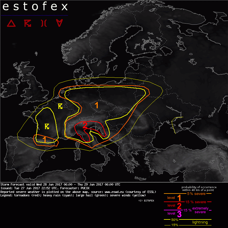
Valid: Wed 28 Jun 2017 06:00 to Thu 29 Jun 2017 06:00 UTC
Issued: Tue 27 Jun 2017 22:52
Forecaster: PUCIK
A level 2 was issued for N Italy, W Slovenia, W Croatia mainly for excessive precipitation, large to very large hail, tornadoes and to the lesser degree for severe wind gusts.
A level 1 was issued for Pyrenees area mainly for large hail.
A level 1 was issued for W Germany and Holland mainly for excessive precipitation.
A level 1 was issued for S, Central and E Germany, Austria, Czech Republic, Slovakia, Hungary, Croatia mainly for severe wind gusts, large hail and excessive precipitation.
SYNOPSIS
At the beggining of the forecast period, a deep, negatively-tilted trough will stretch from W Ireland through S France towards the Balearic Sea. At the SW flank of the trough, a strong jet-stream with windspeeds of up to 60 m/s is forecast with a strong cyclonic curvature at the base of the trough. The base of the trough will eject NE-wards, crossing N Italy, the Alpine range, Austria and S Czech Republic by Thursday 06 UTC. In the southerly flow ahead of the trough, a large warm sector will cover much of S, Central and SE Europe ahead of the advancing cold front. By the end of the period, cold front is forecast to have reached Poland, Slovakia, Hungary and NE Balkans. Across much of the warm sector, abundant lower tropospheric moisture will allow at least for marginal CAPE. Thus, large part of Europe will be under a thunderstorm threat with several areas requiring closer inspection.
DISCUSSION
... W Germany, Netherlands ...
In the trough at the lower troposphere, a belt of enhanced lower tropospheric moisture will cross the area during Wednesday with marginal CAPE mostly below 500 J/kg. Despite rather weak CAPE and also moderate shear at best, elevated risk of excessive rainfall will exist due to the high precipitation efficiency of developing thunderstorms. The main reasons for high efficiency will be low cloud bases and high RH throughout the troposphere. A low-end Lvl 1 is introduced for the area.
(alleen de voor NL en aangrenzende gebiden relevante tekstdelen overgenomen, klik hier voor de volledige forecast, red.)
Verwachtingen/waarschuwingen | Wateroverlast/(zware) neerslag
