
21-07-2016 00:12 | Estofex | m.b.t. 21-07-2016 t/m 22-07-2016
Storm Forecast
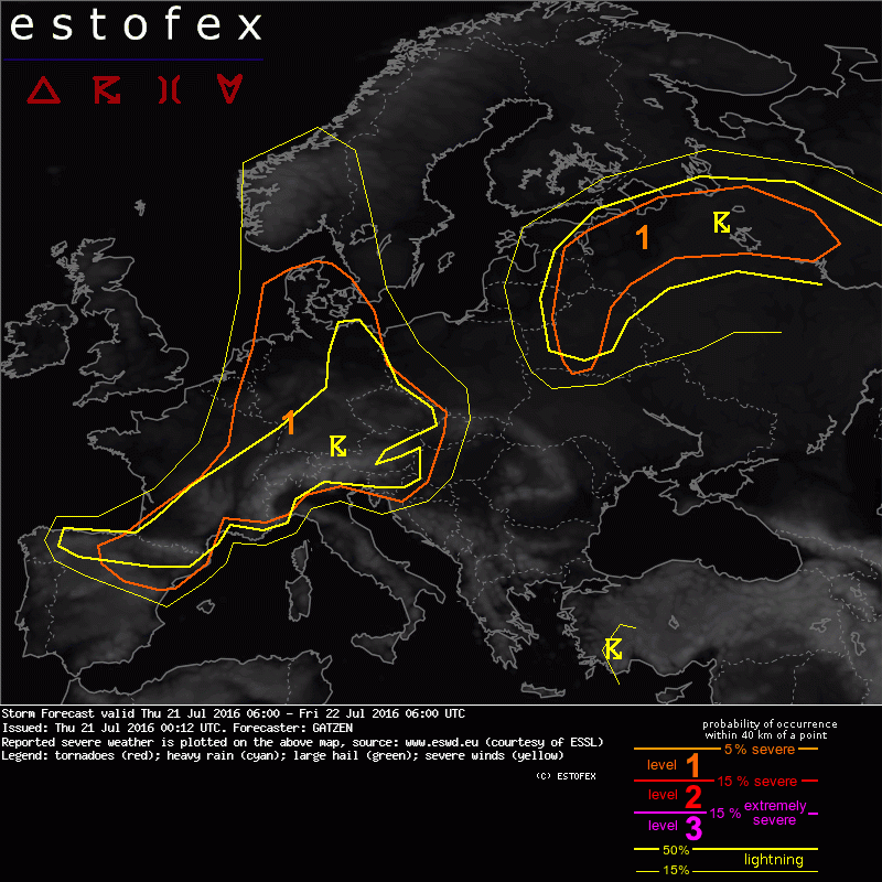
Valid: Thu 21 Jul 2016 06:00 to Fri 22 Jul 2016 06:00 UTC
Issued: Thu 21 Jul 2016 00:12
Forecaster: GATZEN
A level 1 was issued for eastern Benelux and France into Germany, Czech Republic mainly for excessive precipitation and to a lesser entent tornadoes.
A level 1 was issued for the Alpine region mainly for excessive precipitation, large hail and to a lesser extent severe wind gusts.
A level 1 was issued for Denmark mainly for excessive precipitation, large hail, and to a lesser extent tornadoes.
A level 1 was issued for northern Spain and southern France mainly for large hail and severe wind gusts.
A level 1 was issued for western Russia into eastern Baltic States and Belarus mainly for excessive precipitation.
SYNOPSIS
Polar troughs centred south of Iceland and across eastern Europe are associated with a southward extension of the mid-level jet that affects Iberia, the Alps, northern Balkans, and Turkey. In between, ridging from the west Mediterranean towards Scandinavia is interrupted by a vort-max moving east to the north of the Alps. At lower levels, rather cool air masses over north-western and eastern Europe are separated by warm and moist air masses of an occluded frontal system extending from Germany to western Scandinavia. Another plume of warmer air advects from Russia towards the Baltic Sea at the northern flank of the east European trough. Hot air masses remain from Iberia to the north Mediterranean.
DISCUSSION
Eastern Benelux and France into Germany, Denmark, Czech Republic, and Alpine region
A frontal system has entered Germany on Wednesday. Its warm sector is mostly occluded leaving a tongue of moderately warm and moist air behind that affects the forecast region on Thursday. Due to a weak vort-max progressing east causing surface pressure falls over the Alps, the occlusion becomes quasi-stationary over Germany. Along the warm air axis, rich low-level moisture overlaps with modest lapse rates with CAPE around 1000 J/kg possible.
Showers and thunderstorms are expected to re-intensify ahead of the approaching vort-max and spread slowly east during the day. Further showers and thunderstorms can be expected in the moist, weakly capped air mass in the wake of the vort-max in response to diurnal heating.
With weak vertical wind shear, storms will be weakly organized, and groups of storms may develop. Main threat is excessive rain given the moist profiles and weak flow. Tornadoes are not ruled out given the moist and buoyant boundary-layer, especially in the vicinity of outflow boundaries and sea-breeze fronts.
Storms are expected to be more intense in the northern portions of the risk area over Denmark, where slightly stronger vertical wind shear is present as well as over the Alpine region, where both better lapse rates and slightly better vertical wind shear are expected. Some better organized multi- or supercells may form here, capable of producing large hail. Overall threat is a high-end level 1 / low-end level 2.
(Alleen de voor NL en aangrenzende gebieden relevante tekstdelen overgenomen, klik hier voor de volledige forecast, red.)
Onweer/blikseminslag | Tornado/hoosverschijnsel(en) | Verwachtingen/waarschuwingen | Wind/storm (-schade)
