
04-06-2022 12:44 | Estofex | m.b.t. 05-06-2022 t/m 06-06-2022
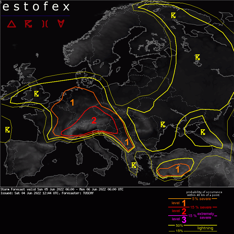
Storm Forecast
Valid: Sun 05 Jun 2022 06:00 to Mon 06 Jun 2022 06:00 UTC
Issued: Sat 04 Jun 2022 12:44
Forecaster: TUSCHY
A level 2 was issued across parts of Switzerland, S/SE Germany, Austria, N Italy to Croatia mainly for severe/damaging wind gusts and large to very large hail.
A level 1 surrounds the level 2 for similar hazards but with less coverage. The level 1s over E France/Benelux and N Germany were issued mainly for heavy rain and a low-end tornado risk (Belgium/the Netherlands).
SYNOPSIS
Ongoing blocking ridge over the CNTRL Mediterranean weakens during the day with its augmented positive height anomalies pushing S towards N-Africa. Along its northern periphery, a mobile ridge moves E over CNTRL Europe with its axis crossing Poland during the night.
A mid/upper cyclonic vortex jut W of the English Channel opens up while moving E with a resulting more zonally aligned flow regime affecting the NE Atlantic towards NW France.
A quasi-stationary upper trough continues to affect SE Europe and in fact another trough approaching from the NW seems to reinforce the main/primary upper trough.
At the surface, a frontal boundary runs from N France/Benelux towards Hungary and further E towards Romania. A diffuse/elongated LL depression evolves over Benelux and modulates this boundary into a gradually lifting warm front over SE Germany into Hungary and a structuring cold front over France.
ICON converged towards GFS/IFS with respect to placement and intensity of the passing short wave. The same for the evolving depression over Benelux/NW Germany with a more modest intensification rate even in most deterministic runs. IFS-ENS members are more tightly clustered compared to yesterday and show a track towards the Netherlands (with a few stronger members more deflected towards the NW). Overall there is good agreement in the geopotential height and MSLP fields.
DISCUSSION
... Parts of E France and N/NW Germany ...
The level 1 was expanded N to cover the risk of slow moving thunderstorms with heavy rain and isolated hail as DLS is forecast in the 10-15 m/s range. Over Belgium/the Netherlands an isolated tornado event is possible along the periphery of the N-ward moving LL depression.
(alleen de voor NL en direct aangrenzende gebieden relevante tekstdelen overgenomen, klik hier voor de volledige forecast, red.).
Onweer/blikseminslag | Tornado/hoosverschijnsel(en) | Verwachtingen/waarschuwingen | Wateroverlast/(zware) neerslag
