
19-02-2022 22:07 | Estofex | m.b.t. 20-02-2022 t/m 21-02-2022
Storm Forecast
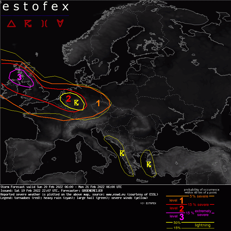
Valid: Sun 20 Feb 2022 06:00 to Mon 21 Feb 2022 06:00 UTC
Issued: Sat 19 Feb 2022 22:07
Forecaster: GROENEMEIJER
A level 3 was issued across western and south-western Scotland, northeastern England, and northern parts of the island of Ireland mainly for severe wind gusts.
A level 2 was issued across large parts of England, Wales, the island of Ireland, the Benelux, and across far northern France and western parts of Germany for severe wind gusts and to a lesser extent for tornadoes.
British Isles, Benelux, France, Germany, and central Europe...
A strong WNW-ESE oriented jet streak with 150-200 kt wind speeds at 300 mb rapidly translates ESE-ward with its right exit quadrant about 600 km west of NW Ireland at 12 UTC, over the Irish Sea at 18 UTC, the southern North Sea at 00 UTC, and north-central France at 06 UTC. Strong quasi-geostrophic forcing for upward motion and resulting destabilization is expected to move in concert with it, which will force linear convection along and behind a cold front that will move southeastward from Western Scotland and Ireland southeastward across the British Isles and reach the Alps on Monday morning.
The front should become defined as a rainband as low-level convergence increases during the morning and the afternoon when it tracks southeastward across Wales and England. The strong background wind field of 30-35 m/s at 850 mb suggests that severe gusts should gradually become an increasing risk. Some very severe gusts of over 32 m/s may occur especially while crossing the North Sea and affecting the Benelux countries.
Convection allowing models suggest that some mesovortices may develop along the line in particular when it moves inland across the Benelux, northern France and western Germany where it encounters strongly helical low-level flow (>400 m2/s2 storm-relative helicity in the 0-1 km layer) This would suggest that an enhanced risk of very severe gusts > 32 to extend inland, as well as a risk of tornadoes.
Limiting factors to their development, however, are the moderate convergence and wind shift along the line, which in the ICON-D2 model yield, fortunately, values of vertical vorticity of about half to two-thirds of those that were predicted for the line that produced multiple tornadoes in Poland early on Friday. Some risk for tornadoes will nevertheless remain. The risk for severe weather overall is expected to slowly diminish as the forcing of the upper-level jet/vorticity maximum slowly weakens toward the morning.
(alleen de voor NL en direct aangrenzende gebieden relevante tekstdelen overgenomen, klik hier voor de volledige forecast, red.)
Tornado/hoosverschijnsel(en) | Verwachtingen/waarschuwingen | Wind/storm (-schade)
