
28-06-2021 18:40 | Estofex | m.b.t. 29-06-2021 t/m 30-06-2021
Storm Forecast
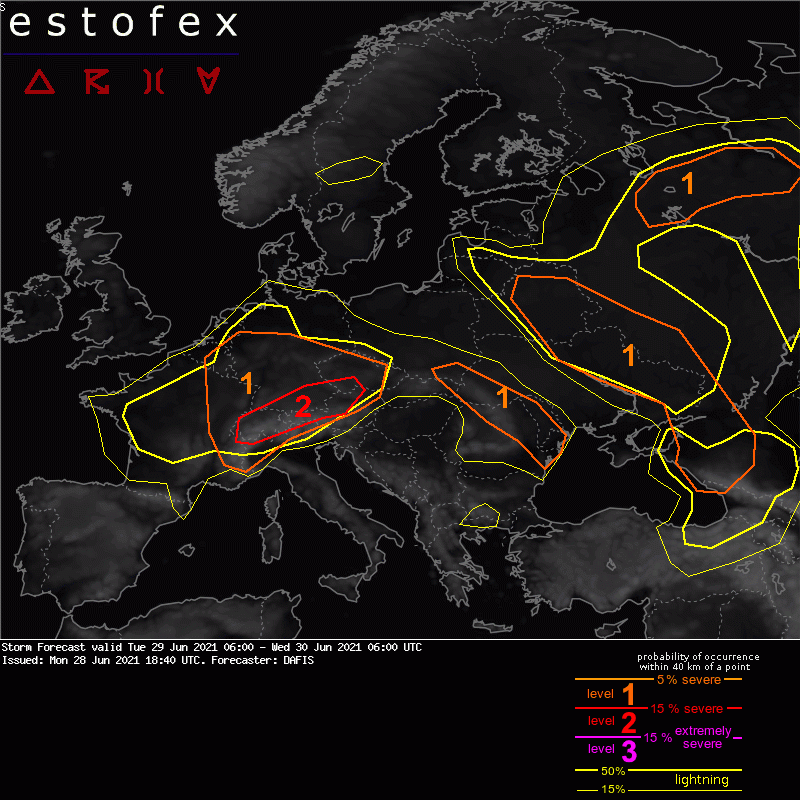
Valid: Tue 29 Jun 2021 06:00 to Wed 30 Jun 2021 06:00 UTC
Issued: Mon 28 Jun 2021 18:40
Forecaster: DAFIS
A level 2 was issued for Switzerland, S Germany, and parts of Austria and the Czech Republic for excessive convective precipitation, large hail, severe convective wind gusts and tornadoes.
A level 1 was issued for France, Luxembourg, S Belgium, Switzerland, Germany, and parts of Austria, N Italy, and the Czech Republic mainly for excessive convective precipitation and large hail.
A level 1 was issued for parts of SE Poland, W Ukraine, E Slovakia, Romania and Moldova mainly for large hail and severe convective wind gusts.
A level 1 was issued for parts of Belarus, Ukraine and W Russia mainly for large hail and excessive convective precipitation.
A level 1 was issued for parts of NW Russia for large hail, severe convective wind gusts and excessive convective precipitation.
SYNOPSIS
A cut-off low over France brings unseasonably cold air masses in western Europe but also pushes warm and moist, and thus unstable air masses towards central Europe where we expect the most severe storms to develop. Another short-wave trough develops in NE Europe and is associated with a surface low-pressure system in Russia, and its almost stationary front will be another hot spot for DMC events. The rest parts of the continent, in Scandinavia and Mediterranean, will be mostly thunderstorm-free except local short-living storms that will develop during the maximum diurnal heating.
(alleen de voor NL en direct aangrenzende gebioeden relevante tekstdelen overgenomen, klik hier voor de volledige forecast,red.)
Hagel(-schade) | Verwachtingen/waarschuwingen | Wateroverlast/(zware) neerslag
