
20-06-2021 00:54 | Estofex | m.b.t. 20-06-2021 t/m 21-06-2021
Storm Forecast
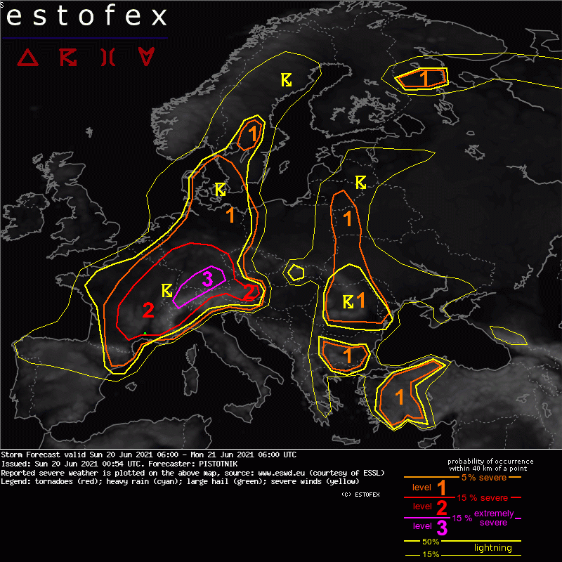
Valid: Sun 20 Jun 2021 06:00 to Mon 21 Jun 2021 06:00 UTC
Issued: Sun 20 Jun 2021 00:54
Forecaster: PISTOTNIK
A level 3 is issued for parts of Switzerland and Germany for severe convective wind gusts and large hail.
A level 1 and level 2 are issued for NE Spain, France and Belgium for severe convective wind gusts, large hail, excessive convective precipitation and to a lesser extent for tornadoes.
A level 1 and level 2 are issued for N Italy, Slovenia, Austria, Switzerland, Germany, Denmark and parts of Sweden for large hail, excessive convective precipitation and severe convective wind gusts.
A level 1 is issued from E Finland into NW Russia for severe convective wind gusts, large hail and tornadoes.
A level 1 issued for Bulgaria, W and central Turkey mainly for large hail and to a lesser degree for excessive convective precipitation and severe convective wind gusts.
A level 1 is issued for Romania for excessive convective precipitation and to a lesser extent for large hail.
A level 1 is issued for the W Ukraine, W Belarus and Lithuania for large hail, severe convective wind gusts and to a lesser extent for excessive convective precipitation.
SYNOPSIS
A long-wave trough stretches from the Norwegian Sea to the British Isles and Spain. Between this trough and a ridge across central Europe, a deep and strong S- to SW-erly flow (20-30 m/s at 500 hPa) advects very warm to hot air as far northward as Sweden and Finland. Two embedded short-wave troughs translate from central Germany (Sun 06 UTC) to central Sweden (Mon 00 UTC) and from Catalonia (Sun 06 UTC) to central Germany (Mon 00 UTC), respectively, and modulate the position of a diffuse, wavy but otherwise stationary frontal boundary. Especially the second short-wave trough will be the main focus for severe thunderstorm activity.
Further downstream, an old cut-off low over Romania, Bulgaria and W Turkey slowly fills and creates unsettled, moderately warm weather in these regions. At its forward flank, another stream of hot air from the Russian plains is directed NW-ward to Belarus and the Baltic States. The Mediterranean region and European Russia are under anticyclonic influence with calm and anomalously warm weather.
DISCUSSION
... NE Spain, France, Switzerland, most of Germany (SW of the Elbe river), BeNeLux ...
The weather pattern brings together the ingredients for organized, long-lived and severe thunderstorms over an exceptionally large area. Steep lapse rates from NW Africa and Spain are advected on top of decent, though somewhat variable, low-level moisture in west-central Europe with 2m dewpoints mostly in the mid- to upper tens. After some hours of daytime heating and supported by a return of strong warm air advection, CAPE on the order of 500-2000 J/kg builds by afternoon and is collocated with 0-6 km shear between 15 and 25 m/s. In general, CAPE is higher towards the SE and shear stronger towards the NW, but the overlap is robust.
At the time of writing (Sat 22 UTC), intense and organized storm activity in the range of the diffuse frontal boundary has spread from France into Belgium, Luxemburg and W Germany. It is expected to overspread most of the W half of Germany in the course of the night while it slowly weakens. Westerly outflow winds will probably push as far eastward as the Czech and Austrian border and align with the north Alpine rim in Switzerland by Sunday morning. With the onset of daytime heating and increasing warm air advection aloft, suppressed vertical mixing in this slightly cooler but moist air can create a "loaded gun" situation with CAPE approaching or even exceeding 2000 J/kg (a similar CAPE amount was already sampled by the Saturday 12 UTC soundings from Payerne and Munich). In addition, surface winds gradually veer from westerly to northerly to easterly directions under the influence of an Alpine heat low. Depending on the balance between this Alpine pumping and a possible downward propagation of hot and dry Foehn winds in the central Alps, the convergence zone may further sharpen and attain the characteristics of a dryline in the course of the day while it is predicted to remain stationary along the north Alpine rim.
Thunderstorm activity on Sunday morning will initially be widely scattered, mostly elevated and poses a limited severe weather risk. It might even completely decay for a couple of hours. As daytime heating proceeds and the lift area of the short-wave trough advances NE-ward, scattered surface-based initiation becomes more and more likely from late morning onwards in NE Spain and S France, from early afternoon onwards in E France and Switzerland, and in the latter half of the afternoon in Germany.
Most forecast models simulate a more or less quick upscale growth into one or two large bowing lines, which can produce widespread severe and even scattered extreme (> 32 m/s) wind gusts, owing both to the strenghtening mid-level wind field and plentiful subcloud evaporation due to the rather high cloud bases. However, the scatter of simulated storm tracks is also extremely large, spanning a more than 500 km wide corridor from Luxemburg in the NW to the German/Austrian border in the SE. These uncertainties can be tracked back on the one hand to inherent difficulties of forecast models to represent an as dynamic and fast-moving feature as this short-wave trough, on the other to the disjunction of lift mechanisms: While the dominant source of lift at low levels is the above-mentioned outflow boundary / dryline near the north Alpine rim, the bulk of the mid-level forcing connected to the short-wave trough will race quickly northeastward across France and Germany. The possible storm tracks are therefore connected to the relative importance of these two lift mechanisms in the "forecast model world".
The mean track of a long-lived bow echo - shall it develop - runs roughly from Bern (Switzerland) towards Leipzig (Germany). While the forecast model pool exhibits a slight overhang towards the northwestern solutions (i.e., driven more strongly by the synoptic lift of the trough), the sheer abundance of CAPE in the loaded gun environment in the Alpine forelands and the more dependable lift along the outflow boundary would be weighty arguments for a more southeasterly track. Taking further into account the higher conditional wind risk in the drier environmental air further SE and the backstop of a possible, more discrete, supercellular storm mode with an additional risk of large to very large hail, the risk level areas are slightly adjusted towards the southeast. Despite these large uncertainties, a level 3 corridor seems to be warranted where both a bowing line with severe to extreme wind gusts or supercells with large to very large hail may occur.
In the course of the evening and night, storms will cross large parts of Germany. They will gradually weaken and become elevated when they outrun the zone of robust CAPE. The hail hazard decreases first, whereas the risk of severe wind gusts and heavy to excessive rain still remains slightly enhanced until Monday morning.
As the short-wave trough and its dominant wave of storms depart, moderate CAPE and moderate to strong vertical wind shear still remain in place across much of France. In the absence of synoptic lift, mesoscale lift mechanisms like thermally or dynamically driven flow convergence over mountains, cross circulations in the range of the diffuse frontal zone, or outflow boundaries take over as possible initiation mechanisms. Scattered storms in form of multicells, supercells or a few large clusters are possible all evening and night long, only slowly tapering off. While storm coverage will likely not be too high, all kinds of severe weather may occur. Next to large hail, severe downbursts and excessive rain, also one or two tornadoes are not ruled out, owing to lower cloud bases and increasing vertical wind shear also across lower levels.
(alleen de voor NL en direct aangrenzende gebieden relevante tekstdelen zijn overgenomen, klik hier voor de volledige forecast, red.)
Hagel(-schade) | Verwachtingen/waarschuwingen | Wateroverlast/(zware) neerslag | Wind/storm (-schade)
