
04-06-2021 00:49 | Estofex | m.b.t. 04-06-2021 t/m 05-06-2021
Storm Forecast
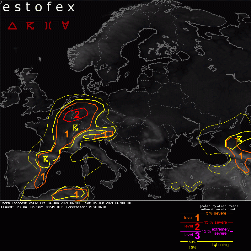
Valid: Fri 04 Jun 2021 06:00 to Sat 05 Jun 2021 06:00 UTC
Issued: Fri 04 Jun 2021 00:49
Forecaster: PISTOTNIK
A level 1 and level 2 are issued for parts of BeNeLux, Germany, France and the Alpine region mainly for excessive convective precipitation and to a lesser degree for large hail and severe convective wind gusts.
A level 1 is issued for parts of Spain, Algeria and Tunisia mainly for large hail and severe convective wind gusts.
A level is issued for parts of Armenia, Georgia and far-SW Russia mainly for large hail and severe convective wind gusts.
SYNOPSIS
Countless small mid-level lows and troughs with slow, erratic motions are distributed across Europe, primarily in a triangle between S Scandinavia, SW Russia and Turkey, and in form of a fragile long-wave trough from Iceland to S France to Portugal. They are opposed a weakening (formerly blocking) anticyclone over NW Russia and a broad, diffuse mid-level ridge over central Europe. Stronger mid-level flow and dynamics are confined to the forward flank of the trough's tips in the W Mediterranean region and the Near East.
At the surface, pressure gradients are - apart from two cyclones over the Black Sea and SW Russia - very weak. The situation is largely barotropic, i.e., the regions under higher 500 hPa geopotential are also placed under warmer (and moister) air, and vice versa.
DISCUSSION
... France, BeNeLux, Germany, Alpine region ...
The warm airmass is characterized by weak lapse rates but plentiful low-level moisture. Over France, BeNeLux and Germany, 2m dewpoints often between 15 and 18C allow the buildup of 500-1500 J/kg CAPE after some hours of daytime heating. Less moisture in the Alpine region keeps CAPE somewhat lower, mostly on the order of 500 J/kg. A few storms may be left over from the previous day or already form in the morning, before quite widespread storms pop up in the afternoon and evening.
Towards the east (Netherlands, most of Germany and the Alpine region), vertical wind shear is weak and the synoptic situation is still rather quiescent, hence mesoscale features like outflow boundaries, insolation gradients and the orography dictate where and when convective initiation happens. The main risk is excessive convective precipitation. The strongest pulse storms near the Alpine rims might also produce marginally large hail or large amounts of small hail, in case the mountains manage to steepen the lapse rates and create a little vertical wind shear by upvalley and upslope circulations. Higher mountains (>2000m) will stay largely devoid of deep convection due to the still abundant snow cover, though.
Further west into Belgium, Luxemburg, far-west Germany and most of France, both deep-layer shear (10-15 m/s) and synoptic lift increase ahead of the long-wave trough. Some storms may therefore organize into multicells or grow into several large clusters. While excessive rain is still the main risk, a few marginally large hail events (with stronger, discrete updrafts) or cold-pool driven severe wind gusts (at the leading edge of storm clusters) are not ruled out in addition. Even though the model pool does not agree on obvious convergence zones, the overlap of CAPE > 1000 J/kg, synoptic lift and abundant precipitation signals appears robust enough to upgrade parts of France, Belgium and far-west Germany to a level 2.
Convection will gradually become elevated and weaken overnight, while it continues to move NE-ward with the lift ahead of the trough.
(alleen de voor NL en direct aangrenzende gebieden relevante tekstdelen overgenomen, klik hier voor de volledige forecast, red.)
Hagel(-schade) | Verwachtingen/waarschuwingen | Wateroverlast/(zware) neerslag | Wind/storm (-schade)
