
24-08-2020 21:56 | Estofex | m.b.t. 25-08-2020 t/m 26-08-2020
Storm Forecast
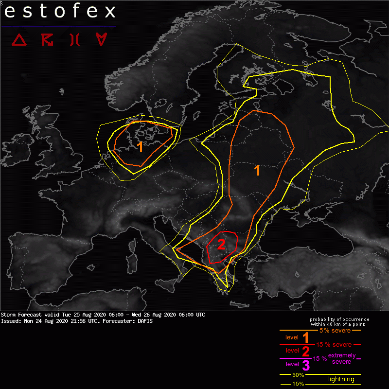
Valid: Tue 25 Aug 2020 06:00 to Wed 26 Aug 2020 06:00 UTC
Issued: Mon 24 Aug 2020 21:56
Forecaster: DAFIS
A level 2 was issued for parts of Albania, North Macedonia, North Greece, South Serbia, and West Bulgaria for large hail, excessive precipitation and severe convective wind gusts.
A level 1 was issued for parts of South Italy, Albania, North Macedonia, Greece, Serbia, Montenegro, Bulgaria, Romania, Moldova, Ukraine, Belarus, Poland, Lithuania, Estonia, Lithuania and Russia, for large hail, excessive precipitation and severe convective wind gusts.
A level 1 was issued for parts of the Netherlands, Germany, Denmark and South Sweden mainly for severe convective wind gusts.
SYNOPSIS
A strong ridge has developed in Eastern Europe while Central Europe is affected by a long-wave trough with an axis extending from Scandinavia towards Central Mediterranean. This trough is associated with a strong PV streamer which is advected east during this outlook, and DMC is expected downstream.
Another interesting synoptic feature will be a short-wave trough that is travelling fast east from the NE Atlantic. By the afternoon on Tue 25/08 its core will be found over the North Sea and a jet-streak is expected to affect a large part of West and Central Europe, resulting in a strong wind-storm.
DISCUSSION
.... Germany, the Netherlands, Denmark and South Sweden ....
A deep surface cyclone is expected to form in the North Sea on Tue 25/08 as a response to a strong mid-level vortex. A jet stream will be wrapped in the southern belt of the cyclone and will affect the largest part of Western Europe with very strong wind speeds that can be translated to the surface. Rather high low-level moisture content ahead of the cyclone may result in convective activity, and inside the level-1 threat area, we expect severe convective wind gusts. Moreover, we expect numerous non-convective wind gusts that can be locally extreme, especially near the coasts. Some brief tornadoes during the night cannot also be ruled out.
(alleen de Voor NL en direct aangrenzende gebieden relevante tekstdelen zijn overgenomen, klik hier voor de volledige forecast, red.)
Verwachtingen/waarschuwingen | Wind/storm (-schade)
