
14-08-2020 07:45 | Estofex | m.b.t. 14-08-2020 t/m 15-08-2020
Storm Forecast
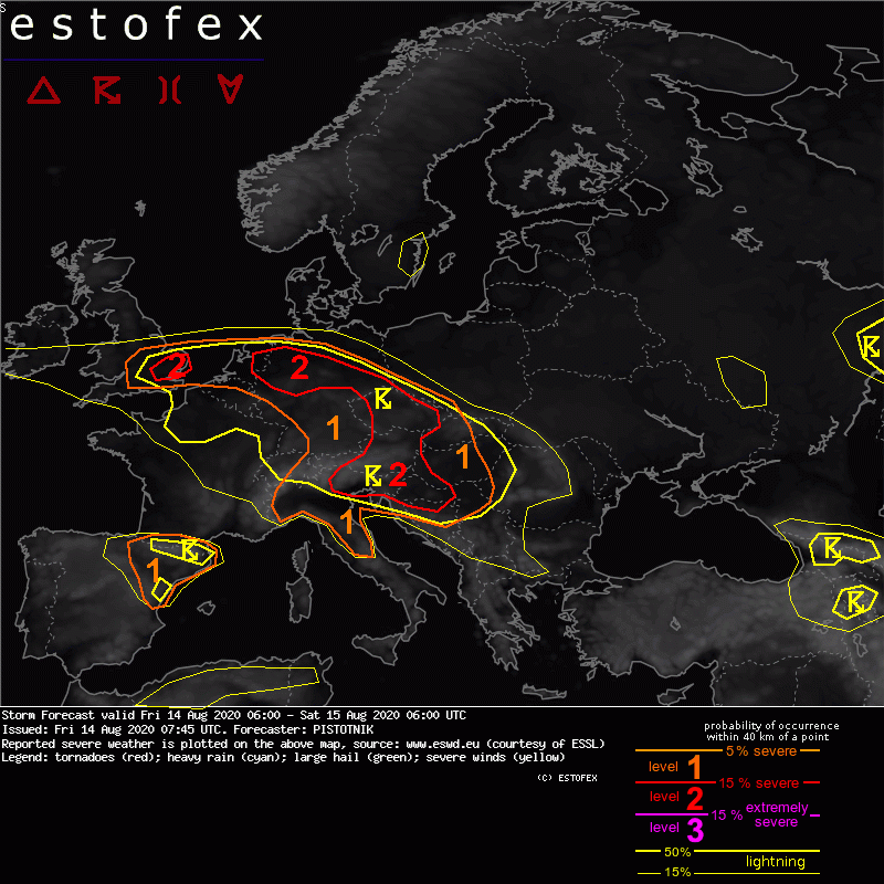
Valid: Fri 14 Aug 2020 06:00 to Sat 15 Aug 2020 06:00 UTC
Issued: Fri 14 Aug 2020 07:45
Forecaster: PISTOTNIK
A level 1 and level 2 are issued for SE England and the Netherlands for excessive convectived precipitation.
A level 1 and level 2 are issued for Germany, the Czech Republic, Slovakia, Hungary, Austria and E Switzerland mainly for excessive convective precipitation and to a lesser degree for large hail and severe convective wind gusts.
A level 1 and level 2 are issued for NE Spain, N Italy, Slovenia, Croatia, Bosnia-Herzegovina and N Serbia for large hail, severe convective wind gusts and excessive convective precipitation.
SYNOPSIS
Weak pressure gradients and warm air cover most of Europe. An axis of slightly higher 500 hPa geopotential stretches from the Balkans to the North Sea. A stationary cut-off low is placed west of the Bay of Biscay.
The main frontal zone runs far north across Iceland and N Scandinavia before it bends southward around a long-wave trough over Russia.
DISCUSSION
... belt from S England to Slovakia and Hungary ...
Very warm, moist and unstable air has settled at the forward flank of the Atlantic cut-off low. A history of widespread (and often severe) storms has "overworked" the airmass, hence lapse rates (and the overall CAPE magnitude) have weakenened, while particularly rich low-level moisture with 2m dewpoints often between 17 and 21C is present. Another day of widespread storms is in store, initiating from late morning onwards along numerous outflow boundaries, other convergence zones, insolation gradients and over orographic features. Very moist air, slow storm motion and weak vertical wind shear provide a prime environment for excessive rain with flash floods. The risk of (marginally) large hail and wet downbursts is reduced by the mentioned convective overturning, but a few events are still possible, especially near the main and leading convergence zone from NW Germany to Slovakia, where the air has not yet been touched by previous convection.
Storms will gradually weaken after sunset, but a few can continue to form throughout the night.
(alleen de voor NL en direct aangrenzende gebieden tekstdelen zijn overgenomen, klik hier voor de volledige forecast, red.)
Verwachtingen/waarschuwingen | Wateroverlast/(zware) neerslag
