
14-07-2007 00:02 | Estofex | m.b.t. 14-07-2007 t/m 15-07-2007
Storm Forecast
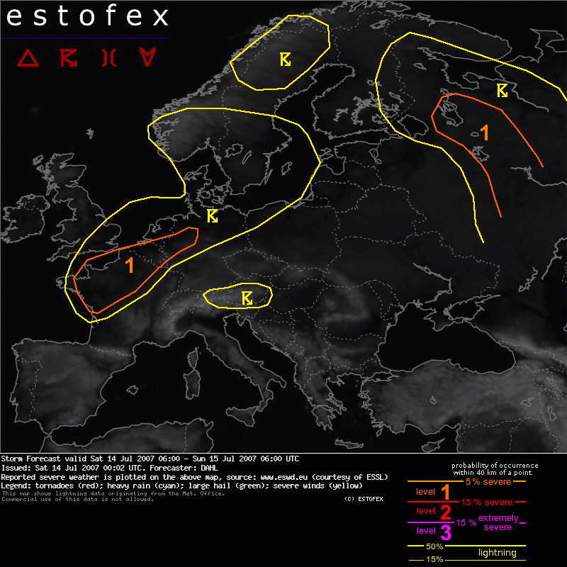
Valid: Sat 14 Jul 2007 06:00 to Sun 15 Jul 2007 06:00 UTC
Issued: Sat 14 Jul 2007 00:02
Forecaster: DAHL
SYNOPSIS
Quite intense upper longwave trough is slowly approaching western Europe. SFC low associated with this feature as well as NEWD tracking peripheral lows, maintained by upper short-wave troughs at the E periphery of the main trough, act to advect warm/moist air over western portions of Europe. Another deep longwave trough is located over the eastern parts of Europe, with a plume of warm/moist air to its east. High pressure prevails underneath the upper ridge between the two longwave troughs, over the Mediterranean regions.
DISCUSSION
... France ... Benelux ... Germany ...
Both, GFS and ECMWF advertise a substantial increase of CAPE in the evening hours and through Saturday night over France, though ECMWF puts the maximum CAPE rather towards southwestern france, while GFS has it over central France. Both models develop precip mainly after 18Z, which is tied to the onset of LL WAA associated with a developing frontal wave.
Thinking is that scattered storms will develop over central and western France in the late afternoon and evening, which will gradually evolve into an elevated MCS during the night, which will persist until Sunday morning. Shear should be well sufficient with up to 30 m/s DLS for a few well-organized storms, including supercells, with a threat for damaging winds and large hail. Shear in the cloud-bearing layer of the nocturnal MCS should be marginal, but isolated severe hail may occur.
Farther downstream over Benelux and Germany isolated to scattered thunderstorms may also initiate during the afternoon hours. These storms will also benefit from 15 to 20 m/s DLS, which should prove sufficient for isolated large hail and severe wind gusts.
Should storms over France and Germany become more widespread than currently anticipated, an upgrade may be necessary.
... Extreme NW Russia ...
Another focus for severe weather should persist over extreme NW Russia, where ample CAPE and 15 to 20 m/s DLS should be present. Main threats should be large hail and damaging wind gusts.
Hagel(-schade) | Onweer/blikseminslag | Verwachtingen/waarschuwingen | Wind/storm (-schade)
