
30-06-2007 15:38 | Estofex | m.b.t. 01-07-2007 t/m 02-07-2007
Storm Forecast
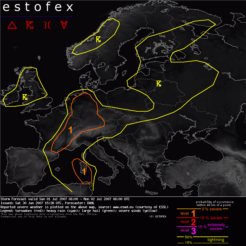
Valid: Sun 01 Jul 2007 06:00 to Mon 02 Jul 2007 06:00 UTC
Issued: Sat 30 Jun 2007 15:38
Forecaster: DAHL
SYNOPSIS
Large-scale Atlantic upper trough and the associated low-level cold front will have reached western Europe early in the period. Until Monday morning, this trough is expected to have attained a considerable negative tilt, extending from the northwest Mediterranean towards the British Isles. A rather strong SFC low is accompanying this feature and will be located over the northern British Isles, making slow northward progress. East of this low, weakly unstable air mass is advected across western and central Europe.
DISCUSSION
... southern France ... Alpine Region ... Germany
Current model guidance suggsts that the warm sector air over France and Germany will be covered with high and - partly precipitating - mid-level clouds, which will limit the degree of destabilization ahead of the cold front. Current thinking is that weak CAPE will still develop locally, especially where cloudiness has been thin enough to allow for some solar heating at the surface. Deep shear will likely be on the order of 20 m/s which will be supportive of organized multicells and mesocyconic storms. However, chances exist that storms will be largely imbedded in stratiform precipitation and maybe fail to become surface-based. However, confidence in at least isolated surface-based evolution along and ahead of the cold front is sufficiently high to warrant a level-one threat. Main risks will likely be marginally severe hail/wind and maybe aso a brief tornadfo or two gven 10 m/s LLS in over portions of the warm sector.
Somewhat less disturbed pre-convective environment may develop further NW over Germany, where GFS' CAPE signals are somewhat stronger. Storms should initiate along the SFC cold front as well as ahead of it along an airstream boundary expected to stretch across the warm sector. Additional topographically-forced storms are possible as well. Deep shear will be on the order of 15 m/s which may be supportive of some organized multicellular storms capable of marginally severe hail/wind. Isolated/brief mesocyclonic storms cannot be excluded, which would augment the hail threat. Best DLS ist current thought to exist over northern parts of Germany. LLS seems to be maximized over central portions of Germany in the evening hours, but likely over regions where CAPE and DLS will be minimized. So it seems that allover severe threat is somewhat marginal.
... western Mediterranean ...
Scattered storms are expected to develop over the western Mediterranean ahead of the southern extension of the western-European long-wave trough late in the period. Given rather strong shear profiles, expect storms to organize into multicells and isolated supercells capable of large hail and damaging winds.
Hagel(-schade) | Verwachtingen/waarschuwingen | Wind/storm (-schade)
