
30-07-2018 01:35 | Estofex | m.b.t. 30-07-2018 t/m 31-07-2018
Storm Forecast
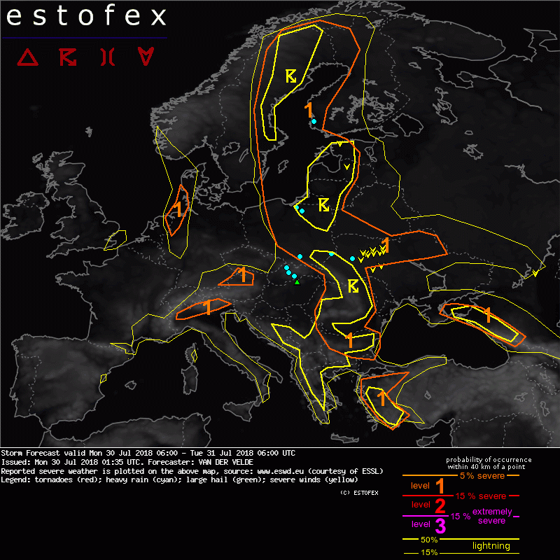
Valid: Mon 30 Jul 2018 06:00 to Tue 31 Jul 2018 06:00 UTC
Issued: Mon 30 Jul 2018 01:35
Forecaster: VAN DER VELDE
A level 1 was issued across W Turkey mainly for large hail.
A level 1 was issued across Bulgaria and Romania mainly for excessive convective precipitation.
A level 1 was issued across Poland and Ukraine mainly for excessive convective precipitation, severe wind gusts and large hail.
A level 1 was issued across the Baltic States mainly for excessive convective precipitation.
A level 1 was issued across N and E Sweden and W Finland mainly for excessive convective precipitation.
A level 1 was issued across N Italy mainly for large hail.
A level 1 was issued across S Germany mainly for large hail and excessive convective precipitation.
A level 1 was issued across E Netherlands, W Germany and W Denmark mainly for large hail and tornado chances.
A level 1 was issued across Caucasus mainly for large hail.
DISCUSSION
An unstable airmass over central Europe is squeezed northwards into Scandinavia and Baltic States between an approaching large Atlantic low pressure system and a Russian high pressure system. An upper low affects western Turkey.
Flow (and shear) is generally weak, which easily can lead to high rain sums because of slow storm motion. Significant vertical wind shear (>10 m/s 0-6 km) exists generally from W Turkey to Caucasus, and near the Atlantic system over a slightly unstable area between S UK, Belgium, Netherlands, W Germany and S Scandinavia.
The highest MLCAPE (over 2000 J/kg) is produced over N Ukraine to Poland, and with delta-Theta-E of 15-25 K can lead to isolated severe wind gusts and large hail. The chance of flash floods is enhanced on the east side of the Carpathian mountains, where strong easterly moisture flow are lifted. A similar but weaker situation occurs downstream across Bosnia and Serbia, as well as N Sweden.
Forcing is generally weak and orographic, or by old outflow boundaries. The only systematic lifting occurs west of a PV feature, across the Estonia, Latvia and Lithuania, and on the east flank of the Atlantic low where shortwave trough pushes through Netherlands, North Sea, Denmark and Norway. In this area GFS is more confident about convective developments than ECMWF and ICON. Presence of 15 m/s DLS and 10 m/s LLS suggests rotation can develop, with enhanced chances of large hail and tornado. At the end of the forecast validity period, a rapidly developing trough passes through SE England with possible convective development.
Cloud base heights are 2000 m or more over W Turkey, parts of Balkan, Germany, Italy, which can promote large hail and severe wind gust chances. The cloud base is forecast to be low over N Sweden, aiding precipitation efficiency.
Verwachtingen/waarschuwingen
