28-08-2016 05:01 | Estofex | m.b.t. 28-08-2016 t/m 29-08-2016

Storm Forecast
Valid: Sun 28 Aug 2016 06:00 to Mon 29 Aug 2016 06:00 UTC
Issued: Sun 28 Aug 2016 05:01
Forecaster: VAN DER VELDE
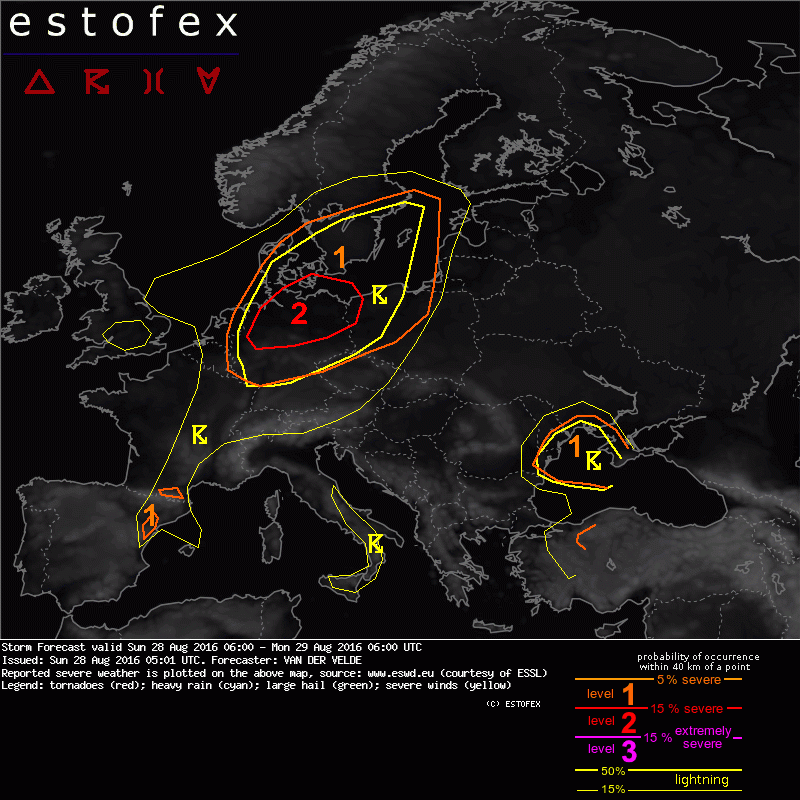
A level 2 was issued for N Germany mainly for large hail and severe convective wind gusts, with isolated tornado chances.
A level 1 was issued for parts of Belgium, Netherlands, Germany, Poland, and southern Scandinavia mainly for isolated severe wind gusts and large hail.
A level 1 was issued for parts of S France and NE Iberian Peninsula mainly for large hail.
A level 1 was issued for N Turkey mainly for isolated large hail.
A level 1 was issued for NW Black Sea area mainly for excessive convective rain and waterspout-type tornadoes.
SYNOPSIS
A mid level trough passes into western Europe, where it produces strong southwesterly flow and cyclogenesis. Under the influence of warm air advection and convective latent heat release, a surface low pressure system is deepening from 1009 to 1002 hPa (GFS) as it moves across the North Sea and Denmark/Sweden today. It develops a frontal structure with a warm front moving northward over Denmark, Sweden and Lithuania, a cold front coming in early through Netherlands, Belgium and France, and Germany and Poland during evening and night. Preceding the forecast period, the warm unstable airmass in the warm sector triggered widespread thunderstorm activity along the southern North Sea advecting into Denmark, where it will degrade into a rainy zone along the warm front. GFS predicts the maximum of CAPE (1500-2000 J/kg) shifting from NW Germany at 06Z to N Poland at 06Z the next day. Other maxima are found in eastern Spain and the northern Black Sea.
DISCUSSION
...Netherlands, Germany, Denmark, Poland...
A broad region with an overlap of steep lapse rates and at least 10 g/kg mxing ratios is in place, with up to 13 g/kg across E Netherlands/NW Germany at 12Z, as well as near the Austrian border. Resulting MLCAPE ranges between 1000-2000 J/kg. However, over southern half of Germany capping is stronger and lifting weaker than in the north, so that convective initiation may be more isolated there.
A broad overlap of instability with 10 m/s 0-6 km shear will be present across the northern half of Germany, good for storm organization, with 15 m/s and 20-25 m/s over N Germany and Denmark/S Sweden respectively, which allow supercells to form, with large hail and/or severe wind gusts. LCLs in GFS are around 2000 m in C to N Germany with only 1000 m over NW Germany moistened by the precipitation of last night. Delta-Theta-E is predicted to be over 20 K which can lead to very cold downdrafts with significant severe wind gusts potential.
Both LFC-LCL differences and uncapped parcel layer depth suggest now that surface-based convection is enabled rather early already between Netherlands and central Germany. The cold front seems not very well defined at the surface, with GFS depicting very little convergence. An upper level lifting mechanism catches up with the cold front only during the evening/night. The likely scenario therefore is development of somewhat isolated storms during late morning and afternoon between E Netherlands and SE Denmark, which likely form supercells, later merging into clusters. Over Denmark, elevated storms can be embedded in frontal rain zones and have supercell characteristics as result of strong effective shear.
Tornado chances are present, especially over Netherlands, N Germany and S Denmark, but 0-1 km shear magnitude struggles to reach the 10 m/s in GFS. It becomes stronger after nightfall along the cold front over NE Germany, which by then has probably formed a linear MCS. The storm motion is rather front-parallel (SW to NE) rather than the W-E of the front itself. This suggests that while a linear MCS can form, its most effective gust fronts will be the ones bending perpendicularly to the SW-NE movement. Such system should be able to persist well into Poland and southern Baltic Sea, perhaps also S Sweden.
(alleen de voor NL en aangrenzende gebieden relevante tekstdelen zijn opgenomen, klik hier voor de volledige forecast,red.)
Hagel(-schade) | Onweer/blikseminslag | Verwachtingen/waarschuwingen | Wind/storm (-schade)