21-07-2016 18:22 | Estofex | m.b.t. 22-07-2016 t/m 23-07-2016

Storm Forecast
Valid: Fri 22 Jul 2016 06:00 to Sat 23 Jul 2016 06:00 UTC
Issued: Thu 21 Jul 2016 18:22
Forecaster: TUSCHY
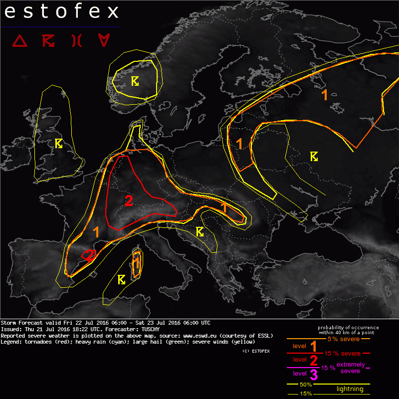
A level 2 was issued for parts of E-France, parts of Benelux, W/S Germany, W-Austria, N-Italy and Switzerland mainly for excessive rain.
A level 2 was issued for NE Spain mainly for large hail and severe wind gusts.
A level 1 was issued for parts of Spain, France, Italy, Alpine regions, Hungary, Slovenia, Slovakia, W-Romania, the Czech Republic, Germany and Benelux mainly for excessive rain and isolated large hail. In addition a few severe downburst events are possible.
A level 1 was issued for parts of the Baltic States and surroundings but also for parts of extreme W-Russia mainly for excessive rain and isolated large hail.
A level 1 was issued for Corsica and Sardinia mainly for large hail and severe wind gusts.
SYNOPSIS
A deep trough over W-Europe sneaks east and starts to split - one parts lifts north over the E-English Channel to the S-North Sea as a short-wave, whereas the southern part continues to amplify towards the W-Mediterranean. This results in a weakening of the mid-level height gradient over CNTRL Europe and a sharpening trend over the far W-Mediterranean.
A closed upper low over E-Europe slides east with a north-south elongated ridge covering an area from Italy to Finland.
At lower levels, numerous frontal zones will be the foci for the main thunderstorm activity: one extending from SE-Spain to E-France to Benelux and far W-Norway. The other one running from the Baltic States to far W-Russia.
DISCUSSION
... Level 2 and 1 area over CNTRL Europe ...
This set-up is characterized by a moist BL with 0-1km mixing ratios of 11-14 g/kg. This offsets marginal mid-level lapse rates of 6.5 to 7 K/km. 500-1000 J/kg MLCAPE with local higher peaks is a reasonable forecast. This is fostered by yesterday's 12 UTC soundings (only the ones not contaminated by convection). DLS remains aob 10 m/s for many regions but increases to 15 m/s from E-Spain, SE-France to N-Italy.
Level 2 area:
This region requires continual nowcast due to the enhanced probabilities for very efficient rain producers with a regionally confined but substantially enhanced flash flood risk!
Lifting mid/upper wave turns the flow more cyclonic and a broad area of weak to moderate upper-level divergence evolves over the aforementioned wavy frontal zone. Passing subtle vort maxes and upper mass divergence result in the development of a diffuse meso-alpha scale low, which rides along that boundary to the N/NE - crossing E-France and residing over SW/W-Germany during the evening and night. Ongoing model discrepancies in respect of strength and placement of that low result in a pretty broad level 2 area to cover the ongoing uncertainties. However, convective allowing models and even coarser ones point to a gradual increase in low-tropospheric moisture with LL mixing ratios of 11-14 g/kg and effective PWATs of 25-35 mm (with regionally higher peaks). CI will be early in the forecast with ongoing storms from the previous night being a likely scenario. Despite this "mess" of storms probably contaminating the air mass on a regional scale (by stratiform rain and thick clouds), air mass recovery is forecast to be fast during day with weak cap and temporal diabatic heating.
During the daytime hours, focus for severe storms will especially arise from E-France to Switzerland, S-Germany and far N-Italy/SW-Austria. Convection my grow upscale into clusters, which could produce severe wind gusts and large hail on a regional scale (due to strong cold pools). Excessive rain will be another hazard, although probably maximized with more isolated and slow moving thunderstorms (storm motion of less than 10 kt with training possible). Foci for training exists along mesoscale convergence zones and along the mountains.
Further north, including parts of Benelux and W-Germany, conditions improve during the day for quasi-stationary thunderstorms, as DLS relaxes to less than 10 m/s and LL flow turns ageostrophically more to the E/NE at low-levels beneath very weak SW-erly mid-/upper-level flow. A growing / unseasonably moist BL and upper-level support offer favorable conditions for thunderstorms with extreme rainfall amounts on a very local scale. This risk continues well into the night and possibly all night long, despite gradually weakening CAPE/ICAPE. A few severe wind gusts (downburst related) and large hail incidents are possible, too.
Level 1 area:
Initiation will be all day long. Thunderstorms from the previous night probably continue during the start of the forecast with a temporal lull in strength. With ongoing diabatic heating and increasing CAPE, the risk for strong to isolated severe multicell thunderstorms increases as daytime hours progress. Initiating and more discrete thunderstorms will be able to produce large hail and strong wind gusts. A few severe downburst events are possible. The main risk however will be excessive rain with clustering thunderstorms and slow storm motions of 5-10 kt. Less moisture and/or weaker forcing especially at lower levels kept this risk in a level-1.
Over E-Spain, SE-France and N-Italy (south of the Alps, where a level 2 was issued), the risk for a few well organized multicells / isolated supercells increases with enhanced deep-layer flow. Large hail and strong to severe wind gusts will be the main hazard, although the risk of excessive rain could also increase betimes as thunderstorms cluster.
Parts of NE Spain were upgraded to a level 2, as 15-20 m/s DLS overlap with decent CAPE, supporting large hail (isolated very large hail possible) with mature supercells. Severe wind gusts are also possible with excessive rain becoming the dominant risk as convection clusters during the evening hours.
(alleen de voor NL en aangrenzende gebieden relevante tekstdelen overgenomen, klik hier voor de volledige forecast, red.)
Hagel(-schade) | Onweer/blikseminslag | Verwachtingen/waarschuwingen | Wind/storm (-schade)