01-06-2016 22:56 | Estofex | m.b.t. 02-06-2016 t/m 03-06-2016

Storm Forecast
Valid: Thu 02 Jun 2016 06:00 to Fri 03 Jun 2016 06:00 UTC
Issued: Wed 01 Jun 2016 22:56
Forecaster: PISTOTNIK
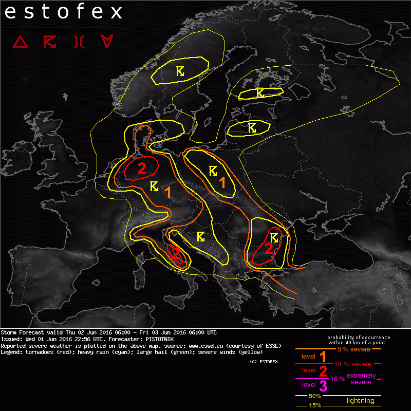
A level 1 and level 2 are issued for Bulgaria and E Romania mainly for large hail and excessive convective precipitation, and to a lesser extent for severe convective wind gusts and tornadoes.
A level 2 is issued for N Germany mainly for excessive convective precipitation and to a lesser extent for large hail and severe convective wind gusts.
A level 1 is issued for parts of Italy, Austria, Germany, Denmark, the Czech Republic, Slovakia, Poland, the SW Ukraine and N Romania mainly for excessive convective precipitation.
SYNOPSIS
A large blocking anticyclone over Iceland and a stationary cut-off low over central Europe are the dominant synoptic features. The center of the cut-off low is located over Austria at 500 hPa, while at the surface numerous mesoscale cores form (and decay) across central and SE Europe into Turkey in response to diurnal heating and pivoting vorticity maxima aloft.
Moist and temperate air is in place over much of the continent. A belt of warmer and particularly moist air wraps around the low from Bulgaria and Romania across central Poland into N Germany, the Netherlands and Belgium.
Stronger westerly mid-level flow is confined to a belt from Tunisia towards Turkey beneath the subtropical jet stream.
DISCUSSION
A few hundred J/kg of CAPE will develop over wide areas in response to diurnal heating. Weak lapse rates aloft and an early initiation of convection will preclude higher CAPE values.
Scattered to widespread, diurnally driven storms will form again under weak vertical wind shear and pose a risk of flash floods, favored by largely saturated soils after plentiful rain in the past few weeks. Due to uncertainties in the detection of convergence zones, which could provide an environment for a higher density of heavy rain events, and due to the limited precipitable water load (mostly between 20 and 25 m/s), most areas are covered with a level 1 only. However, a few areas deserve special attention:
N Germany:
Forecast models agree on the formation of a mesoscale low-pressure core, which shall move towards the Netherlands. Temporary warm air advection from the NE will allow the buildup of higher CAPE up to 1500 J/kg ahead of it and may establish slightly enhanced vertical wind shear. Aided by convergent low-level winds and a pronounced vorticity maximum aloft, widespread storms are expected and will possibly merge into one or two MCSs in the afternoon and evening.
Next to an enhanced risk of flash floods, also localized instances of 2-3 cm sized hail (mostly in an early stage, when storms are still discrete) and severe wind gusts (especially at the leading edge of an MCS) are possible. The regions with the expected highest coverage is upgraded to a level 2.
Storms will likely reach the Netherlands and Belgium in the evening while slowly weakening.
(Alleen de voor NL en aangrenzende gebieden relevante tekstdelen overgenomen, klik hier voor de volledige forecast, red.)
Hagel(-schade) | Onweer/blikseminslag | Wateroverlast/(zware) neerslag