01-06-2016 06:56 | Estofex | m.b.t. 01-06-2016 t/m 02-06-2016

Storm Forecast
Valid: Wed 01 Jun 2016 06:00 to Thu 02 Jun 2016 06:00 UTC
Issued: Wed 01 Jun 2016 06:56
Forecaster: PUCIK
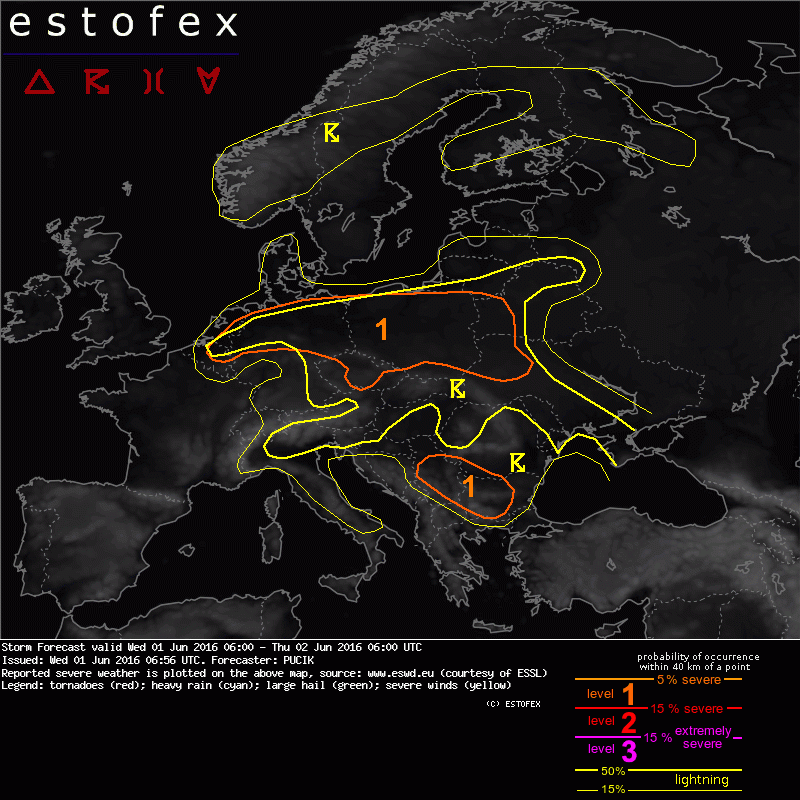
A level 1 was issued for eastern BENELUX through northern Germany, central Czech Republic and eastern Poland mainly for excessive precipitation.
A level 1 was issued for southeastern Serbia and western Bulgaria mainly for large hail.
SYNOPSIS
Major synoptic-scale feature influencing the convective weather over Europe will still be a lingerning large mid to upper tropospheric low that is centered over Austria and neighbouring regions. On its southern flank, a short-wave trough is making its way from N Africa towards Italy and the Balkans area. Isolated to widespread DMC will form over much of central Europe owing to the aforementioned low. However, much of the area will remain in rather marginal instability combined with weak vertical wind shear, limiting the severe weather threat.
DISCUSSION
... Central Europe ...
A rather difficult situation to get a handle on is developing over central Europe. Considerable cloudiness is now observed over west-central Poland through central Germany and BENELUX. There are some hints of clearing, especially over central Poland and northeast Germany, but some areas may remain overcast for much of day. Furthermore, there are big differences between individual numerical models regarding the CAPE and precipitation fields. 00 UTC soundings show potential for excessive precipitation especially in the belt from central-eastern Poland (Legionowo) through northern half of Germany (e.g. Bergen). Surface observations confirm this with 14 - 16 deg C dewpoints in exactly this belt. Several convergence zones are also observed in this area (northwestern Germany and northeastern Poland), but also for example over central Czech Republic. Will issue a Lvl 1 where the best potential for excessive rainfall should exist, but also elsewhere in the region, potential will be there for an isolated excessive rainfall or a marginally severe hail event. Uncertainties however preclude the level issuance.
... Bulgaria to Serbia ...
As a stronger mid-tropospheric flow overspreads the region, DLS will increase to values around or above 15 m/s, increasing chances for well organised DMC. Even though initiation will likely stay isolated, a Lvl 1 seems to be warranted for a possibility of large hail event especially in case that supercells manage to form in this setup.
Verwachtingen/waarschuwingen | Wateroverlast/(zware) neerslag