30-05-2016 03:54 | Estofex | m.b.t. 30-05-2016 t/m 31-05-2016

Storm Forecast
Valid: Mon 30 May 2016 06:00 to Tue 31 May 2016 06:00 UTC
Issued: Mon 30 May 2016 03:54
Forecaster: VAN DER VELDE
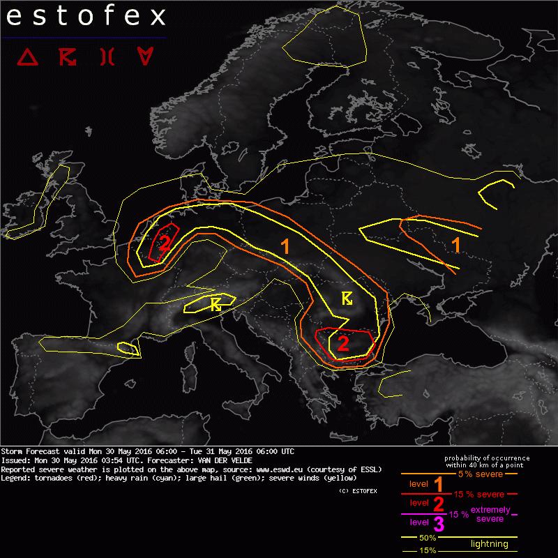
A level 2 was issued for Netherlands, Belgium and W Germany mainly for excessive convective precipitation.
A level 2 was issued for Bulgaria and E Serbia mainly for large hail and severe wind gusts.
A level 1 was issued for N Germany, Poland mainly for isolated large hail and excessive convective precipitation.
A level 1 was issued for Romania mainly for isolated severe convective wind gusts and large hail.
A level 1 was issued for NE Ukraine and W Russia mainly for large hail and severe convective gusts.
SYNOPSIS
A low pressure system spanning much of central and western Europe is centered near Luxembourg today. A low-level plume of warm, moist air is overlaid by moderate lapse rates creating 500-1500 J/kg MLCAPE over N Germany funneling into an almost stationary occlusion with convergent winds over Netherlands and Belgium into N France, slowly shifting westwards. It is dynamically backed by a PV/dynamic tropopause feature over central Germany pushing NW-wards.
Cool air to the south of the low pressure center is still somewhat unstable in a zone from N Spain, SE France, N Italy and Austria. A larger PV band coming from Italy is the main source of lift over the Balkan in the afternoon, where 1000-2000 J/kg MLCAPE may develop in drier air. The apex of the shortwave trough will pass over Bulgaria.
An upper cold pool dwells over Ukraine.
DISCUSSION
...N Germany to Netherlands, Belgium, Luxembourg, W Germany, N France...
A vigorous MCS is ongoing over W Germany at 03Z, moving towards Netherlands and Belgium with 35 kts mid level winds and 900 J/kg CAPE in 00Z Meiningen sounding. It seems quite well placed by GFS 18Z and other models. It may persist into the present forecast or fall apart with stratiform precipitation carrying SW-ward into Belgium and France. It may affect the positioning of the frontal convergence zone and convective precipitation. GFS predicts a continuous flow of CAPE into the occlusion stalled near the DE/NL/BE border, and a PV feature turning towards this zone from S Germany during the afternoon and evening, likely producing a second round of storms focused within the level 2 area, but exact region may be shifted. In this zone storms will move slowly and can offload excessive precipitation.
Over N Germany storms likely develop in late afternoon which would move toward N or E Netherlands. There will be slightly elevated vertical wind shear helping long-lived multicell formation with enhanced severe weather chances.
(alleen de voor NL en aangrenzende gebieden relevante tekstdelen overgenomen, klik hier voor de volledige forecast, red.)
Hagel(-schade) | Onweer/blikseminslag | Wateroverlast/(zware) neerslag