28-03-2016 20:15 | Estofex | m.b.t. 29-03-2016 t/m 30-03-2016

Storm Forecast
Valid: Tue 29 Mar 2016 06:00 to Wed 30 Mar 2016 06:00 UTC
Issued: Mon 28 Mar 2016 20:15
Forecaster: DAFIS
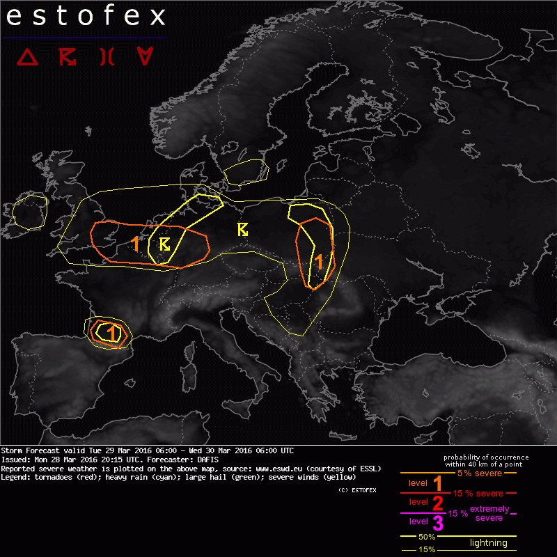
A level 1 was issued for Poland, Slovakia, Ukraine and Hungary mainly for severe wind gusts and large hail.
A level 1 was issued for UK, NE France, Benelux and Germany mainly for severe wind gusts and large hail.
A level 1 was issued for SW France mainly for severe wind gusts and large hail.
SYNOPSIS
Several disturbances affect North and Central Europe, with severe wind gusts causing serious problems while a ridge tries to form in Southern parts of the continent. On the surface, the vigorous low pressure system over the North Sea shifts to the North and several fronts move leisurely to the South. Once again, during Tuesday, widespread but weak instability overlaps with strong wind fields and pose threats at the level 1 areas as shown on the map. The weak instability precludes higher threat levels.
DISCUSSION
.... UK, NE France, Benelux and Germany ....
A broad swath of enhanced directional DLS shear and 100-500 J/kg MLCAPE (decreasing in SW) overlap, as winds at 850 hPa are expected to exceed 20 m/s, thus severe winds gusts are probable, and most so in the region that sees best overlap of instability, shear and forcing with isolated large hail during the afternoon hours within the strongest updrafts. The risk diminishes during the evening and night hours, as CAPE decreases. Thunderstorm probabilities over the English Channel remain augmented with an enduring severe wind gust risk.
.... Poland, Slovakia, Ukraine, Hungary ...
Ahead of the eastward trailing cold front, a strong LLJ supports adequate moisture advection well towards the east. A combination of cold mid-levels, the approaching front during peak time heating and a strong vorticity lobe from the West indicate a temporarily flare up of convection in the highlighted area (after 12z). It is still unclear, how much CAPE will become available, but any stronger updraft grows into a strongly sheared environment (20-30m/s DLS), so an isolated, organized thunderstorm is possible. The main risk will be large hail and strong to severe wind gusts. With 15-20 m/s 0-3 km shear, well-organized storms are expected and the mode of organization will likely be linear.
.... SW France ....
High resolution models produce an overlap of sufficient DLS and CAPE to sustain a DMC event over SW France. AROME in high resolution mode suggest the advection of high Theta-E airmass at lower levels, as cooler mid-level temperatures overspread this airmass, a belt of moderate latent instability is forecast to form with MLCAPE up to 400 J/kg according to AROME and up to 700 J/kg according to WRF runs.
Hagel(-schade) | Onweer/blikseminslag | Verwachtingen/waarschuwingen | Wind/storm (-schade)