15-07-2010 12:00 | Estofex | m.b.t. 16-07-2010 t/m 17-07-2010

Storm Forecast
Valid: Fri 16 Jul 2010 06:00 to Sat 17 Jul 2010 06:00 UTC
Issued: Thu 15 Jul 2010 20:24
Forecaster: TUSCHY
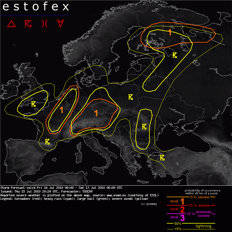
A level 1 was issued for N-Italy, parts of Switzerland, Austria, the Czech Republic and SE/E Germany mainly for excessive rainfall and locally large hail.
A level 1 was issued for parts of France, Benelux and NW-Germany mainly for isolated large hail/severe wind reports and to a lesser extent for an isolated tornado.
A level 1 was issued for parts of Finland and up to the White Sea mainly for large hail, strong to isolated severe wind gusts and an isolated tornado event.
SYNOPSIS
A quasi-stationary low north of Scotland assists in persistent WAA downstream, so ridging over most parts of south/central and eastern Europe persists. A cold front runs from SW-France to NW-Germany and will produce showers/thunderstorms. Main activity regarding deep moist convection will be in the broad warm sector ahead of this boundary.
DISCUSSION
... From NW Italy to Austria to E-Germany ...
It is a bit puzzling, why models like GFS/WRF or GEM show only moderate quantitative precipitation forecast (QPF) signals and even the bullish NGP model does not indicate any significant signals. On the one hand, this scenario can be endorsed, as WAA regime assists in modest geopotential height increase over the area, so the lower/mid troposphere warms up during the forecast and only weak forcing is forecast. However, on the other hand, a very moist air mass infiltrates from the south with surface dewpoints around 20°C and forecast soundings indicate weak cap with 1500 J/kg MLCAPE at an average. In general, at least GFS then develops an unrealistic QPF maximum, whenever initiation occurs in similar environments.
Weak waves at mid-/upper levels may graze the forecast area with initiation forecast next to diurnal driven initiation along the complex topography during peak time heating. So combining weak forcing and capping, modest MLCAPE and a very moist BL, there is no reason, why scattered thunderstorms should not evolve in a weakly sheared environment. Rapid clustering is forecast and next to slow storm motion, orographic effects may locally increase rainfall amounts. Locally excessive rainfall is forecast, as PWAT values top out at 40 mm and more. Isolated large hail can't be ruled out in stronger updrafts. Thunderstorms may organize into multicells in the western part of the level 1 (e.g. NW-Italy, Switzerland, SE / E-Germany and the W-Czech Republic), where 15 m/s DLS overlaps with aforementioned air mass. This may enhance the large hail/strong wind gust risk.
A level 2 may be introduced later on (e.g. SE-Germany, where CAPE magnitude will be maximized) due to excessive rainfall, but modest QPF signals of the model pool preclude a level 2 for now.
Clusters of thunderstorms gradually move to the north/northeast during the night . The heavy rain risk remains augmented.
... France, Benelux and NW-Germany ...
Focus for showers/thunderstorms will be the slowly eastward moving surface cold front, as mid-levels atop that boundary cool down. Models still diverge in how well this overlap will be, but a concentrated swath (regarding space and time) with enhanced convection may evolve. Speed shear is strong (20 m/s at 0-3km and 25 m/s at 0-6km), so showers/thunderstorms may pose a severe wind gust/large hail threat. Despite weak directional shear signals in model data (0-1km layer), T-Td depression will be low and some LL CAPE evolves, so any deviant storm motion may cause enhanced helical inflow with an isolated tornado risk. This risk continues well into the night.
...United-Kingdom ...
Strong to isolated severe wind gusts may accompany showers/ thunderstorms in the highlighted area. LCLs around 600 m and some LL CAPE forecast, so an isolated funnel/tornado event can't be ruled out, mainly during the afternoon hours.
... S-Finland ...
Along and south of a gradually northeastward moving warm front, scattered thunderstorms will develop during the forecast, as warm sector remains weakly capped with good veering throughout the 6 km layer. Multicells or an isolated supercell may evolve with isolated large hail/severe wind gust reports. Storms, traveling along the warm front boundary may also acquire LL rotation with backed surface winds, LCLs below 800m and augmented LL CAPE build-up. An isolated tornado can't be ruled out. GFS indicates an heavy rain risk with storms, moving off the boundary to the north/northeast and becoming decoupled from the BL. The latter risk will continue well into NW Russia after sunset with thunderstorm coverage being on a gradual decrease.
Overall kinematic/thermodynamic overlap is not that extensive, so we only expect a few organized storms and therefore decided to stick with a level 1.
Hagel(-schade) | Onweer/blikseminslag | Tornado/hoosverschijnsel(en) | Verwachtingen/waarschuwingen | Wind/storm (-schade)