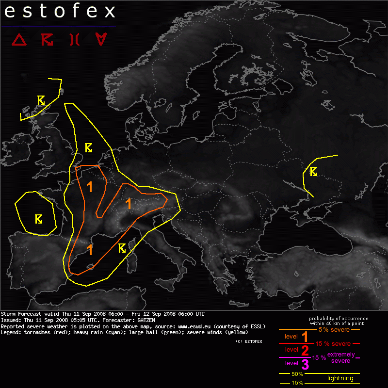
11-09-2008 05:05 | Estofex | m.b.t. 11-09-2008 t/m 12-09-2008

Storm Forecast
Valid: Thu 11 Sep 2008 06:00 to Fri 12 Sep 2008 06:00 UTC
Issued: Thu 11 Sep 2008 05:05
Forecaster: GATZEN
SYNOPSIS
High pressure strengthens over northern Europe. Weak geopotential extends across eastern Europe where intense low-level cold-air advection will continue in the wake of a surface low over south-western Russia. South of the cold front that is expected from southern Poland to Ukraine at THU 12 UTC, warm air mass may be slightly unstable near the upper trough, but low-level moisture is expected to be rather low over Ukraine.
To the west, another trough is flanking the high over western Europe. Warm air mass spreads northward ahead of the frontal boundary from eastern Spain to central France and North Sea. This air mass is characterized by an elevated mixed layer indicated by latest Cagliari 16516 ascend that will likely spread across parts of west Mediterranean during the period. To the north, lapse rates are weaker, but latest models indicate that some instability may develop near the cold front over France due to low-level convergence and moisture pooling as well as over Alpine region where steeper lapse rates may spread northward from the Mediterranean.
Given the blocking high over northern Europe and strengthening easterly low-level winds across central Europe, the cold front over France will likely slow down while the sharp upper trough axis will turn north-eastward, providing strong DCVA. Strong QG forcing along the slow cold front may be associated with widespread convective rain and local flash flooding during the period. The upper trough is expected to cut off over France on FRI.
France, north-west Mediterranean
An elevated mixed layer spreads northward over western Europe. At lower levels, latest soundings show that moisture has started to recover over France and Alpine region. Rich boundary-layer moisture is present over west Mediterranean Sea as indicated by latest Palma de Mallorca sounding. Today, southerly winds are expected, and high low-level moisture will likely spread into southern France ahead of the approaching cold front. In the evening hours, strong QG forcing is expected ahead of the upper vort-max of west-European trough while low-level forcing will also increase along the cold front.
Expect that thunderstorms that have already formed over southern France will go on during the period. While deep layer vertical wind shear is rather weak, supercells seem to be not likely, but increasing southerly winds and low-level vertical wind shear may be sufficient for well-developed multicells, capable of producing intense precipitation. Embedded mesocyclones may also form and a tornado is not ruled out given low LCL heights. Especially in the evening and night hours, widespread convection along the cold front will likely be associated with local flash flooding. Isolated large hail is not ruled out with the stronger cells. Embedded mesocyclones may also develop in the range of outflow-boundaries, and tornadoes are not ruled out. Convection will likely spread to the south and east during the night as the cold front moves on. Over the Mediterranean, high instability of more than 3000 J/kg as well as some vertical wind shear will be present and well-developed multicells are forecast. Large hail seems to be possible during the night hours.
France, Benelux, Alpine region
An unstable air mass has formed over France and Alpine region due to advection of steeper lapse rates from the south and slightly increasing low-level moisture. During the afternoon, a weak mid-level trough now over southern France moves eastward associated with height falls. Given strong low-level heating during the day, thunderstorms will likely develop in the afternoon and evening hours over the Alpine region as well as ahead of the approaching cold front over France. Although deep vertical wind shear is not strong, initial convection may be quite intense, and large hail is not ruled out. To the north, low-level vertical wind shear will increase over the Benelux region, where low-level winds will likely turn to the east, and a tornado is not ruled out in the evening hours. Local flash flooding is another hazard given slow moving storms in the evening and night hours.
Tornado/hoosverschijnsel(en) | Verwachtingen/waarschuwingen | Wateroverlast/(zware) neerslag