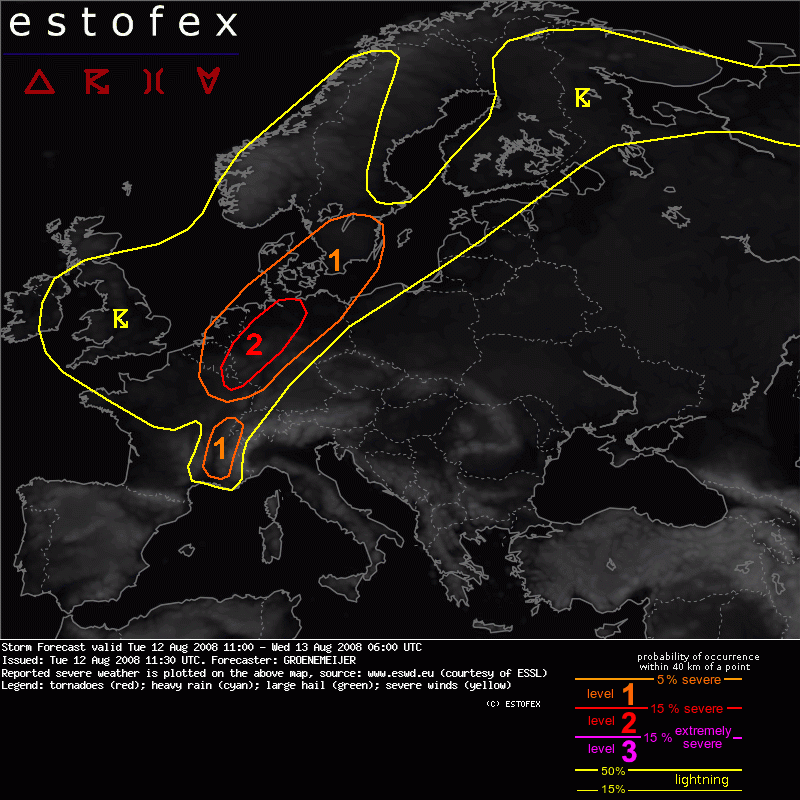
12-08-2008 11:30 | Estofex | m.b.t. 12-08-2008 t/m 13-08-2008

Storm Forecast
Valid: Tue 12 Aug 2008 11:00 to Wed 13 Aug 2008 06:00 UTC
Issued: Tue 12 Aug 2008 11:30
Forecaster: GROENEMEIJER
SYNOPSIS
Not much changes ahead as major upper trough is still in place over NW-Europe. Numerous disturbances rotate around this trough, resulting in unsettled conditions over most parts of central and N-Europe. Still hot and stable conditions over the Mediterranean and SE/E-Europe.
DISCUSSION
A low pressure area over British isles is the most prominent feature on the weather maps. Around an associated mid/upper-level low over Ireland, a strong cyclonically-curved jet extends across northern Iberia via central France into NW Germany.
N France, SE Benelux, NW and N Germany...
Within the section of the jet over western continental Europe, a speed maximum/jet streak over NE France should move northeastward during the remainder of the day. In the lower troposphere, a baroclinic wave has developed. At 11 UTC, the surface cold front of the wave was located near a line from Amsterdam to Luxembourg to Dijon.
Ahead of the surface cold front, surface winds are generally between south and southeast, which creates 100-250 m2/s2 of 0-3 km storm relative helicity. About 500-1000 J/kg of surface-based CAPE is expected here. Strong deep-layer (0-6 km bulk) shear of 25-35 m/s should create an environment conducive to updraft rotation. Relatively high near-surface buoyancy release for surface parcels will probably support low-level rotation as well.
Rotating storms have already been observed by Doppler radar across NE Belgium and SE Netherlands. Further development of a number of small supercells capable of producing tornadoes, possibly including a few strong ones (F2/F3) are expected across the SE Benelux, Lorraine, the Rhineland, Northrhine-Westphalia and Lower Saxony, before moving to north-central parts of Germany later today. Additionally, isolated large hail and some strong/severe straight-line winds are expected.
E Denmark, S and SE Sweden...
These areas will likely be affected by the aformentioned frotnal wave overnight. As it appears as though kinematics will remain favourable for rotating updrafts throughout the night, a few tornadoes may occur here as well even though less buoyancy will be available for surface parcels.
SE France ...
About 25 m/s of 0-6 km bulk shear and 1000-2000 J/kg CAPE should produce an environement conducive of a few, possibly rotating, storms. The main threat of these storms appear to be large hail and excessive rainfall.
Hagel(-schade) | Onweer/blikseminslag | Tornado/hoosverschijnsel(en) | Wind/storm (-schade)