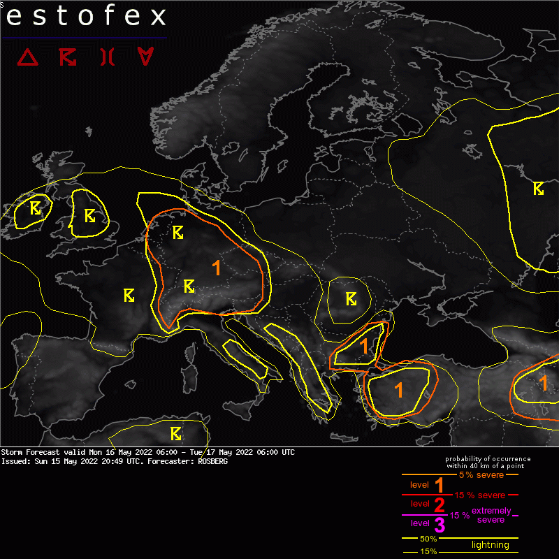
15-05-2022 20:49 | Estofex | m.b.t. 16-05-2022 t/m 17-05-2022

Storm Forecast
Valid: Mon 16 May 2022 06:00 to Tue 17 May 2022 06:00 UTC
Issued: Sun 15 May 2022 20:49
Forecaster: ROSBERG
A level 1 was issued for eastern France, Benelux, Germany and the Alpine region for excessive convective precipitation and to a lesser extent hail and severe wind gusts.
A level 1 was issued for eastern Bulgaria, northeastern Greece and western Turkey for severe wind gusts, hail and to a lesser extent excessive precipitation.
A level 1 was issued for the Caucasus-region, eastern Turkey and northern Iran for severe wind gusts, hail and to a lesser extent excessive convective precipitation.
SYNOPSIS
A stationary longwave upper level trough covers large parts of western Russia and Finland, and is flanked by an upper level ridge over the Norwegian Sea. Upper level ridging is also occurring over the western part of the Mediterranean.
A shortwave trough is expected to pass the UK, northwestern France and Benelux from southwest, while another shortwave trough will move east- and southeastward across the Black Sea region and Turkey. A third shortwave trough/upper level low over the Caucasus-region, eastern Turkey and northern Iran is expected to move eastward towards the Caspian Sea.
At the surface an area of low pressure over northern Russia generates a north and northwesterly flow of cold air over northwestern and western Russia, Finland and the Baltic States with diurnally driven showers and a couple of thunderstorms.
An area of low pressure over northeastern Atlantic generates a southwesterly flow of warm and quite moist air across southwestern, western and central Europe. An associated frontal boundry is located from the UK to western Europe. This frontal zone is expected to move northeastward across central Europe and the North Sea, being the main trigger for deep convection over these areas.
A surface trough over the Caucasus-region and easternmost Turkey is moving eastward, and this surface trough will be the main focus for deep convection over these areas.
A cold front is expected to approach northwestern Spain in the end of the forecast period from west. Despite favorable forcing and lifting mechanisms combined with strong DLS, the mid-level lapse rates will be so weak that the convection will be so shallow that it barely genrates lightning. Thus, no severe weather is expected but a few strong wind gusts cannot be ruled out in connection with the shallow convection.
DISCUSSION
The UK, France, Benelux, Germany and the Alpine region
Showers and isolated elevated storms will be ongoing Monday morning along the frontal boundary across the UK, France, Benelux, southwestern Germany and the Alpine region. As the day progresses and the frontal boundary moves northeastward, shower and thunderstorm activity will increase in coverage and become at least partly surface based. However, storms will remain elevated across the North Sea due to the cold surface water.
The convection will be trigged by the lift from the frontal boundary combined with solar heating. Showers and storms will also form by mountain-valley circulations over the Alps.
Moisture pooling along the frontal boundary with mixing ratios locally over 10 g/kg will contribute to 500-1000 J/kg MLCAPE in connection with the frontal boundary, locally slightly higher. Low deep layer shear, moist sounding profiles with quite low LCLs and preciptable water locally in excess of 30 mm indicate a risk for very heavy rains with these storms with a flash flood threat.
In some spots DLS of 10-15 m/s will make it possible for cells to organize into clusters and/or lines with risk of hail and strong to severe wind gusts.
Behind the front some showers and storms are expected to form across England, Ireland and perhaps also France during Monday afternoon. Convection might struggle to form in France due to weaker lapse rates and some dry air at low- and midlevels.
A couple of hundreds of MLCAPE and 10-18 m/s could generate some multicells with risk of hail and strong wind gusts in these areas. However, the convection does not look to be vigorous enough and coverage to be extensive enough to warrant a level 1.
During the evening and night to Tuesday showers and storms will weaken and become elevated as the frontal boundary will continue eastward into southern Denmark, southwestern Poland, Czech Republic, Slovakia, Hungary and southwestern Romania, with a diminishing wind and flood threat.
(alleen de voor NL en direct aangrenzende gebieden relevante tekstdelen overgenomen, klik hier voor de volledige forecast, red.)
Hagel(-schade) | Wateroverlast/(zware) neerslag | Wind/storm (-schade)