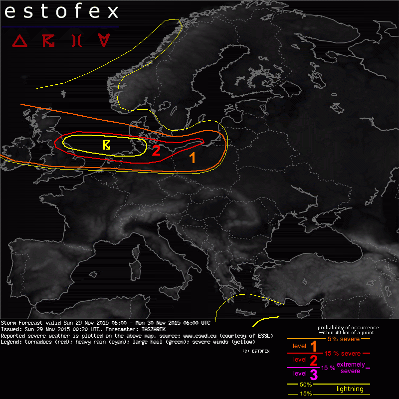
29-11-2015 00:20 | Estofex | m.b.t. 29-11-2015 t/m 30-11-2015

Storm Forecast
Valid: Sun 29 Nov 2015 06:00 to Mon 30 Nov 2015 06:00 UTC
Issued: Sun 29 Nov 2015 00:20
Forecaster: TASZAREK
A level 2 was issued for central UK, North Sea, N Netherlands, S Denmark, N Germany and NW Poland mainly for the damaging wind gusts.
A level 1 was issued for British Isles, Netherlands, Denmark, N Germany and parts of Poland mainly for the severe wind gusts.
SYNOPSIS
A large pressure depression down to 975-970 hPa covers Norwegian Sea, Iceland and northern North Sea. It is encircled by the cyclonically curved powerful jet stream with 300 hPa winds up to 75 m/s. A shortwave with a strong horizontal pressure gradient and an active cold front is forecast by NWP models to pass during the forecast period from central UK trough North Sea, Netherlands, N Germany, S Denmark up to NW Poland where it dissipates. Most of the SE and S Europe is covered with the Azores high that inhibits any convective activity. On the SE edge of the domain where the SLP drops and an unstable air mass occurs, isolated and scattered thunderstorms are possible. Except SE part of the Black Sea, E Europe remains under the cold and stable air mass.
DISCUSSION
...British Isles, North Sea, Benelux, N Germany, Denmark, NW Poland...
A passage of a zonal shortwave will take place in a highly sheared environment with 850 hPa wind speeds up to 35 m/s and a PVA maxima. Except a high risk of an extremely severe wind gusts (33 m/s) due to non convective mechanisms, a presence of a marginally unstable air mass and a QG-lift may involve convection enhancing a wind gust potential. Within the passage of the cold front, a boundary layer's mixing ratios up to 7-8 g/kg and a steepening lapse rates (>7 C/km) provide a CAPE up to 100-200 J/kg on the land and 300-500 J/kg on the sea area. Although instability is not impressive and a free convective layer is forecast to not exceed 4-5 km, a powerful lifting mechanism may organize convection into linear bowing lines capable of damaging wind gusts exceeding 33 m/s. If isolated convective mode will take place, an environment of 200-300 m2/s2 SREH and 25 m/s MLS (most representative for the shallow convectiive layer) will most likely result in low-topped mini supercells . With these, a severe wind gusts and a locall hail up to 2cm may be expected. The most favorable conditions for the lightning occurrence are expected over the North Sea where equilibrium levels will be above graupel formation zones. Over the land, this potential significantly decreases. Current model data forecast that the wave will pass UK around 12 UTC and will move eastwardly reaching Denmark around 21 UTC and Poland around 00 UTC. However, according to some of the mesoscale models, it cannot be ruled out that the wave will move faster. A level 2 denote area where the superimposing large horizontal pressure gradient and the passage of the active shortwave creates the largest threat for the severe and extremely severe wind gusts. A level 1 denote area where shallow convective showers with potential of 25 m/s gusts are plausible. Main limitation of this forecast is related to weak instability over the land areas that may be insufficient to sustain a presence of an organized bowing lines.
Verwachtingen/waarschuwingen | Wind/storm (-schade)