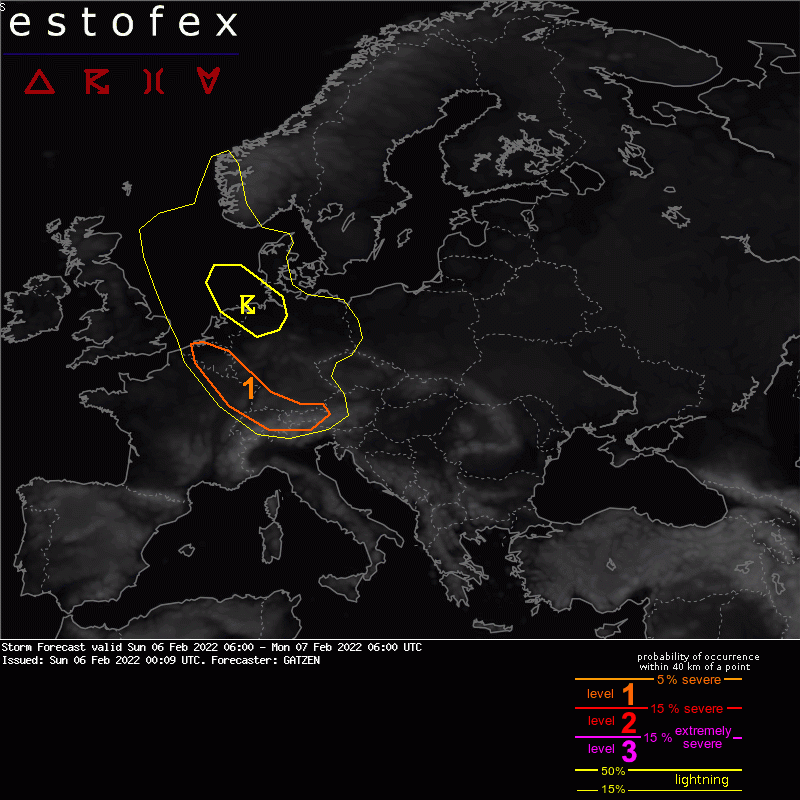
06-02-2022 00:09 | Estofex | m.b.t. 06-02-2022 t/m 07-02-2022

Storm Forecast
Valid: Sun 06 Feb 2022 06:00 to Mon 07 Feb 2022 06:00 UTC
Issued: Sun 06 Feb 2022 00:09
Forecaster: GATZEN
A level 1 was issued across Belgium, north-eastern France, south-western Germany, northern Switzerland, and western Austria, mainly for severe wind gusts.
SYNOPSIS
Across Europe, an amplification of the currently rather zonal flow is expected on Sunday due to downstream development associated with an intense north-east American trough. Impressive details are explosive cyclogenesis south-west of Greenland with a 24-hours central pressure fall exceeding 50 hPa, and a very strong north-westerly mid-level jet streak crossing western Europe in the wake of an amplifying trough.
At lower levels, a frontal wave moves across western and central Europe ahead of the deepening trough, associated with the advection of a moist maritime air mass ahead of the accelerating cold front. The Mediterranean is affected by large-scale sinking in the wake of a short-wave trough progressing across the Black Sea region.
High winds are expected over parts of Europe, including severe non-convective winds along the progressing frontal wave across central Europe and strong Mistral winds developing late in the period.
DISCUSSION
Western and central Europe
A frontal boundary will accelerate south across the area on Sunday. In the afternoon, a frontal wave will be centered over north-west Germany, with a warm front spreading over central Germany and a cold front extending into northern France. The air mass in the warm sector is not expected to be very moist, with low-level dew points around 5°C. However, strong frontal lift ahead of a progressing tropopause fold provides steep low-level lapse rates and a high-shear, low-CAPE environment can develop from Belgium towards the western Alps and southern Germany.
At the western flank of a narrow cold-frontal rain band, a broken lines with some linear segments is forecast, and although these storms will be low-topped, some lightning is forecast due to EL temperature around -20°C. Main threat will be severe wind gusts due to very strong low-level flow. Mesovortices that produce extremely severe wind gusts are not ruled out, but the potential is pretty low given the marginal CAPE expected.
In the wake of the cold front, additional storms are likely to develop in an unstable environment and some lift along the trough axis of the amplifying trough. Showers and thunderstorms are forecast to move south-east from the North Sea and further into Germany and the Benelux countries. Low-level vertical wind shear is strong, and some bowing segments are not ruled out, capable of severe wind gusts. Coverage of these gusts seems to be limited, though, and a risk level is not issued.
Verwachtingen/waarschuwingen | Wind/storm (-schade)