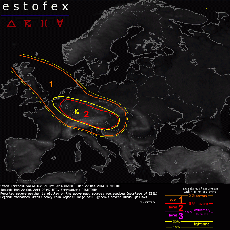
20-10-2014 22:47 | Estofex | m.b.t. 21-10-2014 t/m 22-10-2014

Storm Forecast
Valid: Tue 21 Oct 2014 06:00 to Wed 22 Oct 2014 06:00 UTC
Issued: Mon 20 Oct 2014 22:47
Forecaster: PISTOTNIK
A level 1 and level 2 were issued for SE England, BeNeLux, N and E France, Switzerland, central and S Germany, the Czech Republic and Austria mainly for severe wind gusts and to a lesser extent for tornadoes.
A level 1 and level 2 were issued for NE Italy, the N Adriatic Sea, Slovenia, the N parts of Croatia, Bosnia-Hercegovina and Serbia, and the W parts of Hungary and Slovakia mainly for severe wind gusts and tornadoes, and to a lesser extent for excessive precipitation.
A level 1 was issued from Scotland into NW Germany mainly for severe wind gusts.
SYNOPSIS
A strong zonal flow is present across Europe. A first cyclone tracks eastward into Russia and brings wintry conditions into Scandinavia and northeastern Europe in its wake. Behind a transient and progressive ridge over central Europe, the next cyclone (ex-hurricane "Gonzalo") moves from Scotland towards Denmark, and a new trough ejects from the British Isles into central Europe.
Quiescent conditions prevail over southwestern and southern Europe, apart from quickly increasing Mistral and Tramontana winds over the western Mediterranean Sea at the rear flank of the amplifying central European trough.
DISCUSSION
... England into BeNeLux, NE France, Switzerland, central and S Germany, Czech Republic, Austria ...
A powerful jet streak (>50 m/s at 500 hPa) digs southeastward at the flank of the Scottish cyclone. In the course of the day, its axis is forecast to point across northern and eastern France into Switzerland and northern Italy. Very strong vorticity advection will be present at its cyclonic flank, which is forecast to catch up with the cold front around 09 UTC over southeastern England. Under the influence of its lift, a band of neutral to slightly unstable profiles will likely establish ahead of the cold front, largely overlapping with the very strong wind field of the jet streak.
In the 09 to 15 UTC time frame, thunderstorms become increasingly likely while the cold front moves from England into the Netherlands, Belgium and northern France. Storms will soon organize into multicells and bowing lines, and the risk of severe wind gusts increases betimes. In a strongly sheared and helical flow even in the lowest levels (15-20 m/s of 0-1 km shear and 200-400 m^2/s^2 of 0-1 km storm-relative helicity, respectively), any updraft that manages to stay more discrete may also acquire rotation and produce a tornado.
After 15 UTC the limited area models show convincing signals that the convective activity will be bundled into one dominant line along the cold front, as it moves into Germany, Luxemburg and eastern France. Deep-layer shear increases from 20 m/s near the northern fringe of the unstable area to almost 50 m/s beneath the jet axis over France and Switzerland. A level 2 for severe wind gusts is issued for those areas where a robust overlap of strong shear, strong synoptic lift and at least a little CAPE exists, surrounded by a broad level 1. Limiting factors are the relaxing shear towards the north and the decreasing depth of the convective line towards the south, which makes it less likely that the immense shear beneath the jet axis can be fully consumed.
Until 00 UTC, the convective line is forecast to cross central and southern Germany, the Czech Republic and much of Austria. Along the northern Alpine rim, ageostrophic flow due to channelling (indicated by forecast pressure tendencies up to 10hPa/3h) may further enhance the strength of the wind gusts.
... Scotland and E England, as well as BeNeLux and NW Germany coasts after 15 UTC...
Showers and weakly electrified thunderstorms will form in the stream of deeply mixed polar air behind the cold front. Vertical wind shear will be limited, but the strong background wind field may support wind gusts slightly above 25 m/s even with poorly organized convection. Besides, an isolated tornado is not ruled out along windward coasts where the sudden increase of surface friction ramps up low-level wind shear.
The exact track of the compact center of the cyclone is still uncertain. The majority of forecast models simulate a landfall in Denmark towards the end of the forecast period, which could result in a dramatic increase of wind speeds in a confined area in northwestern Germany near its back-bent occlusion. Since it is unclear how much deep convection will be involved and if this will happen at all until Wednesday 06 UTC, no level 2 was issued.
(alleen de voor NL en aangrenzende streken relevante tekstdelen overgenomen, klik hier voor de volledige forecast.)
Verwachtingen/waarschuwingen