20-09-2014 12:00 | Estofex | m.b.t. 20-09-2014 t/m 21-09-2014

Storm Forecast
Valid: Sat 20 Sep 2014 09:00 to Sun 21 Sep 2014 06:00 UTC
Issued: Sat 20 Sep 2014 09:55
Forecaster: PISTOTNIK
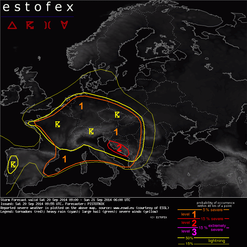
A level 1 and level 2 were issued for parts of the western and central Mediterranean, central Italy and the western Balkans for large hail, severe wind gusts and excessive precipitation.
A level 1 was issued for Switzerland, S Germany, Austria, N Italy, Slovenia and Hungary mainly for excessive precipitation and to a lesser extent for large hail.
A level 1 was issued for France, BeNeLux, N Germany, the Czech Republic, SW Poland and Slovakia mainly for excessive precipitation.
SYNOPSIS
A broad westerly flow covers most of Europe. To the south, a flattening ridge is present over the central Mediterranean. To the north, a small upper-level low slowly moves eastward over Belarus and a trough starts to dig southeastward over Scotland and the North Sea.
Surface pressure starts to drop from Scandinavia into east-central Europe ahead of the latter trough. In response, the low-level flow gradually turns from southwesterly to westerly, and the advance of the broad plume of warm and moist air onto the continent comes to a halt.
DISCUSSION
... western and central Mediterranean into western Balkans ...
00 UTC soundings uniformly show extreme CAPE values between 1500 and 4000 J/kg over the Western and Central Mediterranean Sea, owing to unseaonally rich maritime moisture (surface dewpoints often between 20 and 24°C) beneath an elevated mixed layer that originated from Northwestern Africa. A strong cap has precluded, and will continue to preclude, thunderstorm development over much of this extreme CAPE reservoir. However, to the North, lift associated with travelling vorticity maxima erodes the cap and allows convective initiation. With deep-layer shear often between 20 and 30 m/s, any storm that forms and persists can quickly organize very well.
A very active and very large convective complex has formed overnight in north-central Italy and is moving eastward over the Adriatic Sea at the time of writing (Sat 09 UTC). It exhibits extraordinarily high lightning activity and cloud tops. Further storms are currently initiating ahead of that complex over the Dinaric Mountains in Croatia and Bosnia-Hercegovina. Rich low-level moisture and the high coverage of storms can result in a number of flash floods. Besides, large hail and severe wind gusts are possible especially in case of embedded supercells. An isolated tornado is not ruled out in coastal areas of Croatia, Bosnia-Hercegovina and Montenegro where low-level shear and veering are enhanced.
In the wake of this storm complex, a stout cap remains in place. Isolated storms may form in the afternoon over the Appennin mountains and (less likely) at the sea breeze front along the Spanish East coast. In the evening and overnight, initiation is not ruled out ahead of the next short-wave troughs over the western Mediterranean region, including the Balearic Islands and Corsica.
Coverage of storms will remain low, but due to the high conditional probability of severe weather a level 1 was issued for the northwestern Mediterranean region along with a low-probability thunder area. Large hail, severe wind gusts and excessive precipitation can occur if storms manage to survive the strong cap or even grow upscale.
... larger Central Europe ...
Above the nocturnal cold air pools, elevated mixed layers of limited depth can be found as far north as Szeged, Vienna, Munich, Stuttgart, Trappes and Brest in the 00 UTC soundings. Further north, lapse rates are weaker but this is compensated by particularly rich low-level moisture in a broadly converging wind field from BeNeLux across northern Germany into east-central Europe.
After clearing clouds and morning fog enable some hours of sunshine, CAPE up to 1000 J/kg can build, and another round of scattered to widespread afternoon storms will form. Deep-layer shear is around 10 m/s, slightly increasing towards the south. Excessive rainfall events may be scattered across the entire level 1 area. The regions from the main Alpine crest (which will likely be one of the most important place of initiation) southeastward into northern Italy, Slovenia and Hungary also face an enhanced risk of isolated large hail and marginally severe wind gusts with strengthening shear and steepening lapse rates.
Activity will slowly weaken but likely not fully die overnight.
Verwachtingen/waarschuwingen | Wateroverlast/(zware) neerslag