
26-07-2021 02:26 | Estofex | m.b.t. 26-07-2021 t/m 27-07-2021
Storm Forecast
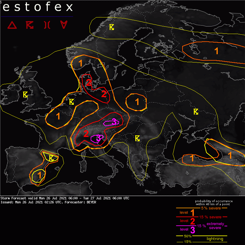
Valid: Mon 26 Jul 2021 06:00 to Tue 27 Jul 2021 06:00 UTC
Issued: Mon 26 Jul 2021 02:26
Forecaster: BEYER
A level 3 was issued along the northern Alpine rim in Austria mainly for (very) large hail, (extreme) severe wind gusts, and excessive precipitation.
A level 3 was issued for parts of Northern Italy mainly for (very) large hail, (extreme) severe wind gusts, and excessive precipitation. A tornado is not excluded.
A level 2 was issued for the surrounding Greater Alpine region mainly due to the same threats but with less likelihood for extreme events.
A level 2 was issued for Northeastern Germany into Denmark mainly due to excessive precipitation.
A level 1 was issued for parts of Central Europa for locally excessive precipitation.
A level 1 was issued for Eastern Poland mainly for excessive precipitation
A level 1 was issued for Eastern Spain mainly for excessive precipitation and severe wind gusts.
A level 1 was issued for Northern Turkey and Caucasus mainly for excessive precipitation and large hail and to a lesser extent for severe wind gusts.
A level 1 was issued for parts of Northwestern Russia mainly for severe wind gusts.
SYNOPSIS
A long-wave trough is persistently situated over Western Europa that has an independent center over NW France and the North Sea. Central and Eastern Europe are lying on the forward flank of this through in a diffluent upper-level flow. Warm and humid airmasses are present in all of this area.
Several short wave features are traveling northeastward leading to maxima in the omega field, responsible for the different regions of interest.
The trough axis is situated over E Spain and travels slowly eastward throughout the forecast period.
Another but weaker trough can be found over SE Europe. NE Turkey and the Caucasus region is situated on its forward flank.
NW Russia is influenced by the rear flank of another trough. A cold front is passing this area from north to south. Thereafter cool airmasses spread that region with a northwesterly flow.
DISCUSSION
... NE Germany into Denmark ...
A maximum in LL moisture overlaps with instability. As a result, 1000 to 1500 J/kg of MLCAPE are forecasted. Along a LL convergence zone storms are forecasted to initiate during the day. Precipitable water is high with values around 35 mm. Having this rather persistent convergence zone and only moderate storm movement, high to excessive amounts of precipitation are expected that may result in local floodings. Even a few extreme events with more than 40 l/qm in less than 1h or more than 60 l/qm in a few hours with repeated convection are possible.
The LVL 1 surrounding the LVL 2 also has the risk of excessive precipitation. Lower PWAT values and lower coverage minimize this threat, though.
(alleen de voor NL en direct aangrenzende gebieden relevante tekstdelen zijn overgenomen, klik hier voor de volledige forecast, red.)
Verwachtingen/waarschuwingen | Wateroverlast/(zware) neerslag
