
22-07-2021 20:07 | Estofex | m.b.t. 24-07-2021 t/m 25-07-2021
Extended Forecast
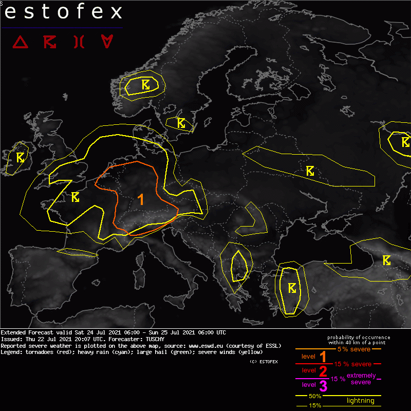
Valid: Sat 24 Jul 2021 06:00 to Sun 25 Jul 2021 06:00 UTC
Issued: Thu 22 Jul 2021 20:07
Forecaster: TUSCHY
A level 1 was issued across Benelux and parts of W-Germany mainly for excessive rain and isolated hail.
A level 1 was issued for far E France to Switzerland into S/CNTRL Germany mainly for hail, severe wind gusts and heavy rain. An isolated tornado is possible.
A level 1 was issued across far N Italy for hail and severe wind gusts.
SYNOPSIS
Blockish pattern persists as an upper trough with an embedded distinct vortex approaches England/Belgium until 06Z. Downstream positive 500 hPa geopotential height field with gradually lowering anomalies betimes covers E-Europe into S-Scandinavia but both features remain progressive during this forecast (hence no real blocking event).
Another trough is parked over SE Europe (Turkey) with no real net motion in any direction while the S-Mediterranean remains hot and dry.
ICON/GFS/IFS show stable solutions with a good intra-run consistency. Subtle differences exist with weak short waves, but this uncertainty hopefully subsides in the future runs.
Complex pattern of MSLP geometry over W-/CNTRL Europe yields a dominant/eastward propagating despression over the Normandy and an eastward arching channel of lower surface pressure towards Benelux, bending SE to Germany. Geometry with this channel/strength differs, although all models agree in the overall configuration.
DISCUSSION
... Far E France, Switzerland into Austria and Germany and Benelux ...
The general pattern is favorable for an active thunderstorm day over CNTRL Europe. Diffluent steering flow turns more divergent during the day with improving jet configuration in a weakly/moderately capped air mass. (Sub)tropical history features TPWs in the 30-40 mm range with slack mid-level lapse rates. Squeezed height field between the French/English vortex and a NE-ward expanding subtropical ridge over Algeria causes a strong SW-erly wind field, pushing kinematics in the range supportive for better organized updrafts from E-France/Switzerland into Germany/W-Austria (0-6 km 15-20 m/s and 0-3 km 10-15 m/s, decreasing towards Benelux).
Current thoughts are that residual convection from the previous night with a diurnal weakness shifts from NE France into Germany until noon and is bound to the surface pressure channel (still able to produce a few heavy rainfall events over Belgium, Luxembourg into far W Germany). Drier BL air filters in from the SE and should suppress CI until it approaches NW/N-CNTRL Germany during the afternoon hours (then producing slow moving convection with rain issues). TPWs increase to 40 mm in its wake.
Another push of WAA is noted from France ahead of the steering depression, which spills rich BL moisture with Tds in the upper 10s/lower 20s into Luxembourg and W/SW Germany while TPWs decrease to 30-35mm - caused by drier air at mid-levels entering the scene from the SW, increasing potential instability (with weak/modest QG forcing from the SW) and offering the highest MLCAPE values of the day in these areas (1000-2000 J/kg from Belgium/Luxembourg to S Germany during the afternoon/evening).
Expect scattered CI beyond noon with organized multicells producing hail and healthy rainfall rates (probably a mixed mode). Current focus for CI resides along the second WAA feature/LL confluence zone and hence over NE France into SW/CNTRL Germany. Of concern is augmented 0-3km shear, which strengthens until the evening with some better curved hodographs in that layer. Hence, better streamwise vorticity for deviating cells increases the risk for rotating updraft with large hail/severe wind gusts. An isolated tornado is certainly possible in case a more discrete cell evolves in this low LCL setup. In case of upscale growth, bowing segments with strong/severe gusts are possible, too. Current focus for this enhanced wind gust/isolated tornado risk resides from N-Switzerland to SW/CNTRL Germany, but this could still change with new data.
Heavy to excessive rain is an issue everywhere especially with merging cells and initiating convection along the orography.
A lull in activity seems to become established towards W Germany into Belgium with competing forcing mechanisms. Overall I do not trust the very reluctant models as forecast soundings still show weak/non-existent capping and some diurnal heating. Subsiding synoptic conditions including temporal mid-level CAA seem to suppress CI in model fields, but this weakens towards the late afternoon hours with an approaching wave from the SW. In addition, the orography should do its job and hence we added this whole area into a level 1 mainly for excessive rain with slow moving cells (with an isolated hail risk in strongest updrafts).
The activity weakens during the night with some flare up over the S North Sea, where a nocturnal elevated cluster may evolve.
... S-UK ...
Slow moving convection within the deformation band brings high rainfall amounts. Good ventillation aloft and a mean storm motion of 5 m/s should support a few heavy rainfall reports although a weakening/decoupling inflow from Benelux should keep this risk in check. EPS data has a few higher members, but otherwise nothing to justify a level area for now. Could see a small upgrade, if more aggressive IFS verifies (right now still an outlier) but general progressive nature of this deformation band should keep these probs. low.
(alleen de voor NL en direct aangrenzende gebieden relevante tekstdelen overgenomen, klik hier voor de volledige forecast, red.)
Hagel(-schade) | Verwachtingen/waarschuwingen | Wateroverlast/(zware) neerslag
