
16-06-2021 23:15 | Estofex | m.b.t. 17-06-2021 t/m 18-06-2021
Storm Forecast
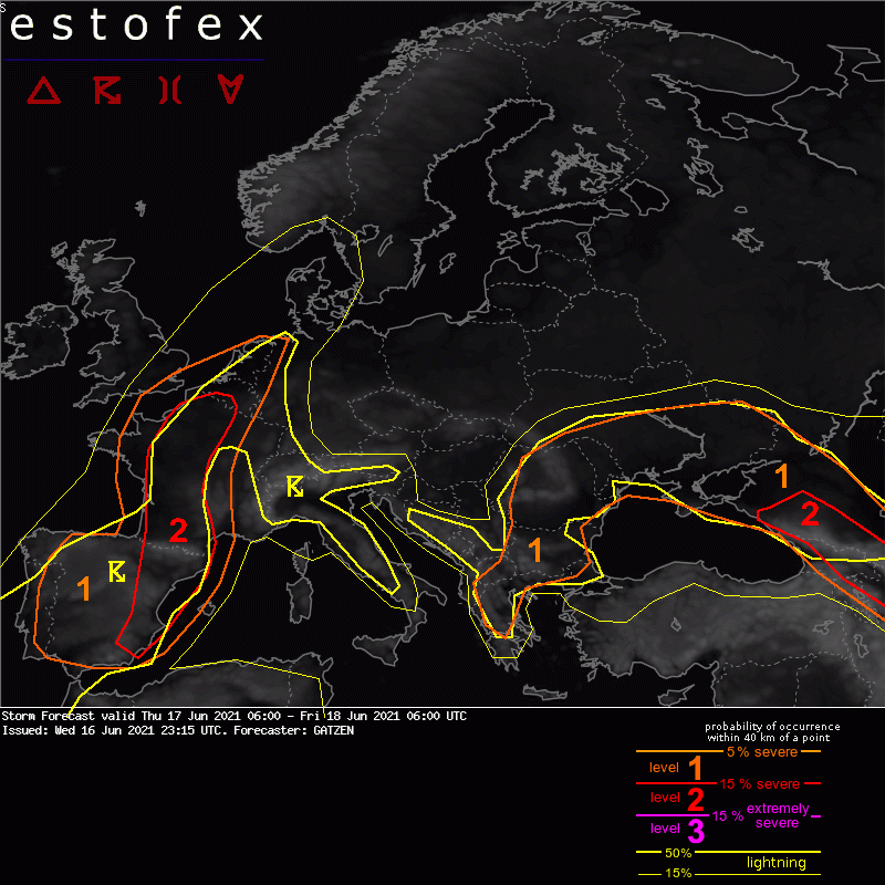
Valid: Thu 17 Jun 2021 06:00 to Fri 18 Jun 2021 06:00 UTC
Issued: Wed 16 Jun 2021 23:15
Forecaster: GATZEN
A level 2 was issued across eastern Spain and central France for large hail and wind gusts.
A level 2 was issued across the Caucasus region for large hail and wind gusts.
A level 1 was issued across France and eastern Spain for severe wind gusts and locally very large hail.
A level 1 was issued across the Channel and the Benelux countries for severe wind gusts.
A level 1 was issued across western Iberia for large hail and extreme rainfall.
A level 1 was issued across Ukraine and Moldova for extreme rain and large hail.
A leevel 1 was issued for southern Romania, Bulgaria, Rebulblic of northern Macedonia and northern Greece for extreme rainfall.
SYNOPSIS
A blocking ridge is centred across north-eastern Central Europe. A closed mid-level vortex affects the Balkans and Black Sea region. An amplified trough is present across the north-eastern Atlantic, with a deep southerly flow dominating across western Europe.
Within the ridge, dry low-level air masses will not allow for any deep moist convection. Humid air masses are pushed southward into the Ukraine where a convergence zone still exists. This moisture also partly overlaps with steep lapse rates advected eastward at the northern flank of the closed mid-level vortex. Another area with rich moisture is present over western Europe. Along a frontal boundary, CAPE can build in response to diurnal heating. At the same time, lifting short-wave troughs will lead to rather strong synoptic forcing.
DISCUSSION
Eastern Spain to central France
A negatively tilted short-wave trough will lift across eastern Spain and central France between Thursday noon and early Friday morning. It will provide DCVA sprrading northward. This will support frontogenesis in the affected area, with warm air advection spreading northward along and west the frontal boundary. Rich low-level moisture of more than 10 g/kg is expected, but mid-level lapse rates are not too impressive yet. It depends on the degree of diurnal heating if sufficient surface-based instability can develop. Clouds from overnights convection can limit the potential over some of the forecast area.
A level 2 was issued for the area where strongest lift will occur. Convective storms are forecast to spread north starting across south-eastern Spain at noon and reaching the Benelux countries late in the period. These storms will profit from strong vertical wind shear, with 20+ m/s deep-layer and 10-15 m/s 0-3 km bulk shear. Widespread sstorms are forecast to organize along their cold pools, with forward propagating multicells that can develop bow echoes. Swaths of severe wind gusts and possible some extremely severe wind gusts are forecast. If high instability can develop in the pre-storm environment, a dercho may result. However, current thinking is that the late development across France dueing the night and clouds will limit instability and some smaller wind-producing mesoscale convective systems will develop rarther than a very huge system.
Furthermore, additional storms are expected to develop along the frontal boundary across central France in the afternoon and early evening. These storms will be more isolated and will develop into clusters of storms later on. Strong deep-layer shear and moderate CAPE will allow for some well-organized storms, and supercells are forecast, capable of large and locally very large hail. Severe wind gusts are also expected with these storms. The widespread convection that is approaching from the south late in the period will merge with the remaining storms.
The MCS will likely become elevated in the northern part of the level 2 and the risk of severe winds will gradually decrease in the morning.
(alleen de voor NL en direct aangrenzende gebieden relevante tekstdelen overgenomen, klik hier voor de volledige forecast, red.)
Onweer/blikseminslag | Verwachtingen/waarschuwingen | Wind/storm (-schade)
