
16-08-2020 20:45 | Estofex | m.b.t. 17-08-2020 t/m 18-08-2020
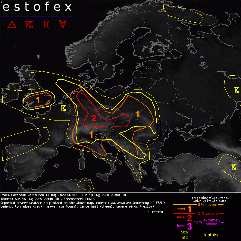
Storm Forecast
Valid: Mon 17 Aug 2020 06:00 to Tue 18 Aug 2020 06:00 UTC
Issued: Sun 16 Aug 2020 20:45
Forecaster: PUCIK
A level 2 was issued across Germany into northern Austria, northwestern Hungary and western Slovakia mainly for excessive rainfall and to the lesser degree for large hail and severe wind gusts.
A level 1 was issued across southern UK and in a belt from northern Netherlands through Germany into northern Italy, Bosnia, Serbia, Poland and Ukraine mainly for excessive rainfall and to the lesser degree for large hail and severe wind gusts.
SYNOPSIS and DISCUSSION
Synoptis-scale situation will be dominated by a trough stretching from the Atlantic into central Europe and a ridge from the Black Sea towards southern Scandinavia. Stronger mid and upper tropospheric flow is forecast over southern flank of the trough and northern flank of the ridge. Within the trough itself, mid-tropospheric flow will stay below 15 m/s. A small-scale vortex will be attached to the trough and will slowly progress from southern towards northern Poland.
An area of enhanced lower tropospheric moisture with mixing ratios between 10 and 14 g/kg is forecast over southern UK and in a belt from northern Netherlands through Germany into the Alpine / Carpathian region and parts of the Balkans. Combined with mid-tropospheric lapse rates of 6 to 6.5 K/km, the moisture will allow for MLCAPE values reaching 500 to 2000 J/kg, generally increasing towards south.
Weak to no synoptic-scale forcing is simulated over the region of interest. Thus, initiation will depend on the local (outflow) boundaries and topography. It is likely that at least isolated storms will be ongoing at the start of the forecast domain in a belt from Netherlands to northern Italy and over Slovakia. Their positioning and leftover cloud cover may strongly impact the local development of CAPE and new storm initiation in the afternoon hours. Two strong moisture boundaries are anticipated across southern Netherlands / western Germany and across northeastern Germany. These may also aid with the initiation of storms.
In general, forecast Skew-T profiles and hodographs suggest storms organised into multicells with slow motion and efficient heavy rainfall (suggested by high moisture content + low LCLs + significant warm cloud depth) processes. Therefore, flash flooding will be the primary concern during this forecast period. Local downbursts and/or isolated large hail events are also not ruled out with stronger cells, particularly over the southern part of the highlighted area with higher CAPE values.
Hagel(-schade) | Verwachtingen/waarschuwingen | Wateroverlast/(zware) neerslag | Wind/storm (-schade)
