
14-08-2020 23:51 | Estofex | m.b.t. 15-08-2020 t/m 16-08-2020
Storm Forecast
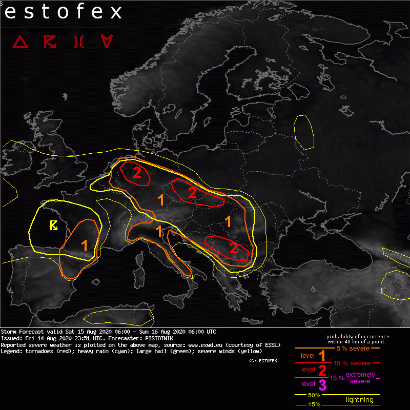
Valid: Sat 15 Aug 2020 06:00 to Sun 16 Aug 2020 06:00 UTC
Issued: Fri 14 Aug 2020 23:51
Forecaster: PISTOTNIK
A level 1 and level 2 are issued from the Netherlands across central Germany, the Czech Republic, Slovakia and E Hungary to the central Balkans for excessive convective precipitation, large hail and severe convective wind gusts.
A level 1 is issued for Belgium, W and S Germany, Austria, W Hungary, Slovenia and Croatia mainly for excessive convective precipitation.
A level 1 is issued for S France for large hail, severe convective wind gusts and excessive convective precipitation.
A level 1 is issued for NE Spain and Italy mainly for large hail and to a lesser degree for severe convective wind gusts.
SYNOPSIS
Weak pressure gradients and warm air cover most of Europe. A weak but extensive antiyclone is centered over the North Sea at 500 hPa and over Belarus and the Ukraine at the surface. A cut-off low over the Bay of Biscay slowly approaches France.
The main frontal zone runs far north across Iceland and N Scandinavia (which is crossed by a pronounced cold front) before it bends southward around a long-wave trough over Russia.
Changes compared to Friday are very small.
DISCUSSION
... Central Europe to Balkans ...
Very warm, moist and unstable air wraps around the forward flank of the Biscayan cut-off low. After several days of widespread convection, the airmass is characterized by plentiful moisture (2m dewpoints often between 17 and 21C, precipitable water around 40 mm) but meagre lapse rates, which largely confine CAPE to values around 500 J/Kg. Numerous, mostly daytime-driven storms are once more expected on Saturday along outflow boundaries, other convergence zones, insolation gradients and over orographic features. They will follow erratic, outflow-driven tracks and may grow into some large, disorganized clusters.
Very moist air, slow storm motion and weak vertical wind shear provide a prime environment for excessive rain with flash floods. A few large hail events and severe downbursts are possible as well, mostly near the leading convergence zone from NW Germany to Slovakia as well as over the Balkans, where the air is previously untouched by convection and allows still steeper lapse rates and more CAPE up to 1500 J/kg. Over the Balkans, deep-layer shear around 10 m/s can also allow some multicellular organization, which further favors in particular the hail risk.
(alleen de voor NL en direct aangrenzende gebieden relevante tekstdelen zijn overgenomen, klik hier voor de volledige forecast, red.)
Hagel(-schade) | Verwachtingen/waarschuwingen | Wateroverlast/(zware) neerslag | Wind/storm (-schade)
