
04-06-2020 23:59 | Estofex | m.b.t. 05-06-2020 t/m 06-06-2020
Storm Forecast
Valid: Fri 05 Jun 2020 06:00 to Sat 06 Jun 2020 06:00 UTC
Issued: Thu 04 Jun 2020 23:59
Forecaster: PISTOTNIK
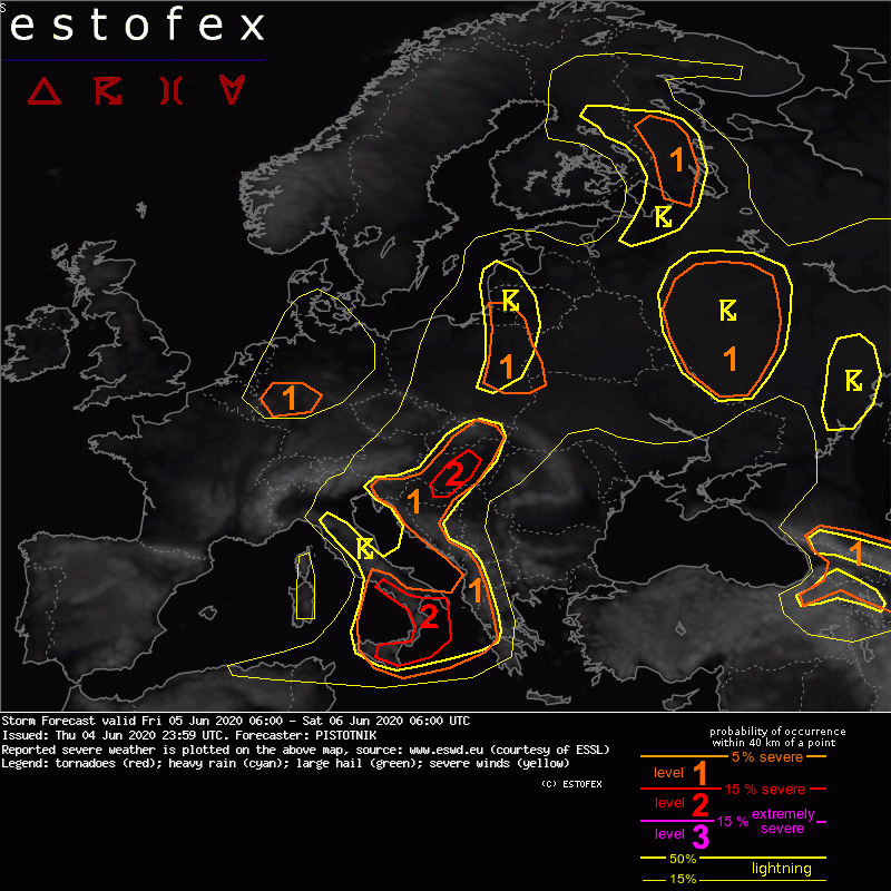
Level 2 areas are issued for S to central Hungary and for S Italy mainly for excessive convective precipitation, severe convective wind gusts, large hail and to a lesser degree for tornadoes.
Level 1 areas are issued for Albania, Montenegro, parts of Bosnia-Herzegovina, Croatia, Slovenia, Hungary, Slovakia, parts of Poland, the Russian exclave of Kaliningrad, and parts of W and NW Russia mainly for excessive convective precipitation and to a lesser degree for large hail and severe convective wind gusts.
A level 1 is issued for W Germany for severe convective wind gusts and tornadoes.
A level 1 is issued for NE Turkey, Georgia, Armenia, Azerbaijan and the Russian Caucasus region mainly for large hail.
SYNOPSIS
A complex and dynamic weather pattern with heavy cyclonic activity influences most of Europe. A dominant cyclone, pronounced at all levels, has settled over the North Sea.
At its forward flank, an occluded frontal system initially stretches from S Finland towards the Ukrainian/Russian border and swings northeastward into Russia. A second, more pronounced frontal system emerges from the core of the North Sea low and affects a broad region from S Scandinavia to the central Mediterranean Sea. Over Poland, it opens up into a warm front that initially extends to the central Black Sea and crosses Lithuania, Belarus and the Ukraine in this forecast period, and into a cold front that initially stretches to the Tyrrhenian Sea and Tunisia and moves east, delayed by a subtle wave development behind the Alps. In its wake, a stream of maritime polar air from the North Atlantic is advected across the British Isles into central Europe. An embedded comma feature gradually organizes into a third frontal system, helped by diurnal heating over land, while it crosses BeNeLux and Germany.
Each of these three features is accompanied by convective activity, which can partly organize thanks to an overlap with enhanced shear beneath mid-level jet-streks and/or areas of strong synoptic and mesoscale lift. In order to tame this otherwise very chaotic setup, they are discussed in chronological order below.
More quiescent conditions under warm air masses are confined to the SE (Turkey and Near East) and SW of our forecast domain (Iberia).
DISCUSSION
... comma / emerging third frontal system: BeNeLux, N France, Germany ...
Daytime heating creates marginal CAPE, especially at the forward flank of a strong vorticity maximum in the left exit of a 40 m/s mid-level jet. Scattered, low-topped convection is predicted. Synoptic lift, and hence the chances for showers to become deep enough for limited lightning, are maximized across BeNeLux and NW Germany, whereas vertical wind shear rapidly increases towards the south. Depending on the amount of daytime heating, a limited overlap of sufficient lift and enhanced shear is possible from NE to W Germany. A level 1 is issued for low-topped multicells, supercells or bowing lines with a risk of isolated severe wind gusts or tornadoes. The main time frame is from 12 to 18 UTC.
(alleen de voor NL relevante tekstdelen overgenomen, klik hier voor de volledige forecast, red.)
Verwachtingen/waarschuwingen
