
10-07-2007 09:49 | Estofex | m.b.t. 10-07-2007 t/m 11-07-2007
Storm Forecast
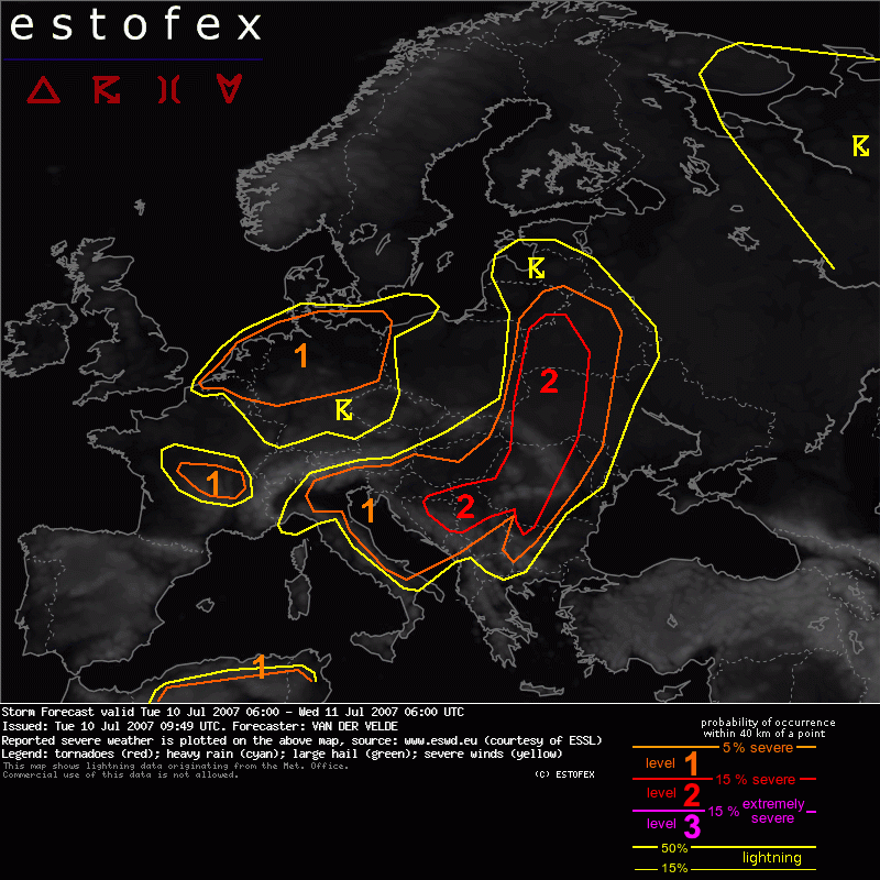
Valid: Tue 10 Jul 2007 06:00 to Wed 11 Jul 2007 06:00 UTC
Issued: Tue 10 Jul 2007 09:49
Forecaster: VAN DER VELDE
SYNOPSIS
A large middle/upper level low centered over southern Scandinavia extends deep into Europe, with the pool of cold mid levels covering southern Denmark into Benelux, central France, Alpine region, Czech Republic and Germany, with most CAPE forecast over northern parts of this area. A complex pattern of shortwave troughs which circle around the large low and the associated differential vorticity advection creates QG lift that is likely to have a clustering effect on convection along with more continuous precipitation, especially over France during the morning, Alpine region/N Italy during the afternoon, reaching finally also the Croatia region during the next morning with very strong forcing. Another wave is coming down over the North Sea to affect the Netherlands and Denmark during the evening, but seems to be associated with warmer middle levels, so stability should increase.
Several shortwaves are present in the tight flow at the east side of the low, from Italy over western Balkan, Poland and Baltic states. The associated surface low pressure area lies over northern parts of the theta-e surge with a thermal trough and convergence zone extending all the way to the Adriatic Sea. Stronger CAPE and shear are present in this large area.
A third large area of instability is associated with another upper low over northern and central parts of Russia.
DISCUSSION
...W Balkan, Romania, W Bulgaria, W Ukraine, Belarus...
A convergence zone along the cold front is positioned at the eastern edge of a strip of high boundary layer moisture, low LCLs and strong deep layer shear zone while steeper lapse rates and high LCLs (>2500m) are placed to the east. Fairly dry mid to lower levels suggest a threat of evaporation-driven severe gusts with the stronger storms.
While deep layer shear is not forecast to overlap much with the convergence zone, moderate DLS should be available to convection in most places, with SREH in the range of 100-250 m2/s2. This enhances the organisation of storms to long-lived multicells and supercells, which both may cause damaging (very) large hail and gusts.
Most instability and deep convergence is progged by GFS00 over W Ukraine into Belarus, where also broadest area of SREH and low level shear (7-10 m/s) is forecast. An isolated tornado is especially in this area possible with a focus point at the occlusion (NW Belarus/SE Lithuania). However, chances are good that by evening the storms in this area have merged into a squall line with a main threat of severe gusts. This is suggested by the transverse acceleration of the moisture axis near the surface low.
...N Italy, N Adriatic...
Strong deep layer shear (mostly 1-8 km rather than 0-6 km) and weak instability (GFS may underestimate this though) could yield an isolated supercell or two at the shortwave passage during the evening and night, when coverage may increase. Arrival of cold airmass over hot Adriatic waters during the night creates strong low level lapse rates and buoyancy, which supports strong waterspouts/tornadoes while the zone is also in strong deep layer shear. These may affect the coast of Slovenia through Croatia.
...Benelux, Germany area...
Very weak winds and strong low-level buoyancy under the cold pool create high chances of numerous waterspouts and landspouts. This has already been confirmed yesterday over UK and the Netherlands. Profiles such as 00Z ETGB Bergen are very favourable, while also the less unstable looking profiles will have significant SBCAPE when temperatures go to 17-18 degrees.
The weakest 10m winds and strongest buoyancy are progged over Netherlands and northern Germany, where the level 1 is drawn.
A necessary convergence zone for spinning up vorticity is currently (07-08Z) present over Netherlands to Denmark along the coast and moving inland. Suspect are any storms in regions where 10m winds are weak or from erratic directions. Slow moving thunderstorms may create local flash flooding.
The southeastern UK sees rapidly decreasing instability but may have favourable conditions for spouts initially.
Besides this area, isolated spouts may also occur from SE Finland into Russia.
...central France...
Despite very marginal CAPE, MU EL heights are okay for thundery convection. Lift is strong and shear conditions are good: up to 30 m/s DLS and 12 m/s LLS, with SREH 100-250 m2/s2, LCLs below 600 m. This suggests that a cell may develop updraft rotation with chances of tornadogenesis, if organised convection manages to sustain itself at all.
Onweer/blikseminslag | Tornado/hoosverschijnsel(en)
